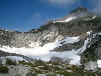
Vesper, Sperry & Wolf Peaks
Hiking to moderate scrambling to intermediate alpine rock climbing in the Mountain Loop Highway area. Enjoy views of the surrounding peaks. In summer, the trail leads nearly to the top of Vesper Peak, so go in early spring for a snow scramble.
getting there
Drive the Mountain Loop Highway east from Granite Falls for approximately 28 miles, turn right on Sunrise Mine Road (Forest Road 4065), and drive 2.3 miles to its end at the Sunrise Mine Trailhead (2,350 ft).
on the trail (APPROACH)
headlee pass (4,720 ft) & vesper lake (4,950 ft)
7.0 miles round trip, 2,600 feet of elevation gain, difficulty: strenuous
Hike the Sunrise Mine Trail 2.7 miles to Headlee Pass at 4,720 ft. From the pass, follow trail skirting around the south flanks of Sperry Peak to the upper Vesper Creek basin between Sperry and Vesper Peaks. Campsites are available on grassy bench near trail above stream, or farther upstream near a small lake in the basin.
ASCENT ROUTE
vesper peak (6,214 ft)
8.o miles round trip, 4,000 feet of elevation gain, difficulty: strenuous 3, technical 3
In late summer many hikers climb Vesper Peak since a trail goes most of the way to the summit. During the rest of the year expect snow travel. During winter and spring this is also a backcountry ski destination however skiers should be prepared for a river crossing.
sperry peak (6,120 ft)
8.0 miles round trip, 3,800 feet of elevation gain, difficulty: strenuous 3, technical 3
Travel east around the lake and up to the saddle between Vesper and Sperry Peaks, then follow a boot path to the summit of Sperry Peak. The path becomes indistinct at times, and the route up the West Face is steep scrambling. Near the summit, follow the Northwest Ridge.
sperry & vesper peaks
10.0 miles round trip, 5,800 feet of elevation gain, difficulty: strenuous 5, technical 3
Scramble Vesper and Sperry Peaks in any order from the basin and connecting them via the Vesper-Sperry saddle.
wolf peak (5,820 ft)
8.0 miles round trip, 3,600 feet of elevation gain, difficulty: strenuous 3, technical 2
On the ridge between Vesper and Sperry Peaks and not named on most maps, scramble to it's top alone or in combination with Vesper and Sperry Peaks.
vesper peak/north face (6,214 ft)
8.0 miles round trip, 4,000 feet of elevation gain, difficulty: intermediate rick climb (Grade II-III, 5.7-5.8)
ascent route
From basin, hike up the scramble trail toward the head of the basin. But angle off trail, bearing to the high first notch in the ridge dividing Vesper’s north and east aspects, not to the lower, more prominent pass at the basin head. The “high” notch leads to a long ledge system that crosses north face (see the photo and route topo in Cascade Alpine Guide, Vol. 2). Scramble the ledge to near its end.
true grit (5.8, 4 pitches)
Starting here, the route consists of two Class 4 pitches followed by three class 5 pitches, but is not obvious. Climb or scramble the first two pitches to a small ledge. From ledge, pitch 3 traverses leftward and ascends a small shallow chimney (5.5-5.6) to belay. Pitch 4 again bears leftward on slabs (5.5). The final long, runout pitch works rightward to slightly west of summit (5.8).
Ragged Edges (5.7, 6 pitches)
This is the 5.7 variation that is on the eastern half of the North Face and the direct start begins at a large flake. Ragged Edges was retro-bolted in some places in August of 2013 and there are still some old pitons along the route. Generally done in 6 pitches.
Descent Route
Scramble down east slope to camp in Vesper Creek basin.
Trip Profile
| SEGMENT | TIME (HR) | ELEVATION GAIN (FT) |
|---|---|---|
| Trailhead to Camp | 3-4 | 2,500 |
| Camp to Summit | 4-5 | 1,615 |
| Summit to Trailhead | 3 |
Equipment
Small to medium stoppers and cams. Crampons/ice ax in early season.
Notes
Described with two (easy) days in mind, this climb can be done in one long day. The North Face has many variations with different degrees of difficulty. Route is very hard to protect and belay anchors are difficult to locate.
Information for Leaders
Scheduling
This route allows multiple bookings. Please check scheduled trips listed below in the "Activities" tab to see if there is another group already booked on the same day. Leaders are expected to contact the leader(s) of existing trips to ensure there are no concerns or conflicts, according to The Mountaineers Outdoor Ethics Policy. Please review our Group Size & Multiple Bookings page for guidance.
- Suitable Activities: Climbing, Day Hiking, Scrambling
- Seasons: July, August, September, October
- Weather: View weather forecast
- Difficulty: Strenuous 3, Technical 3, Intermediate Rock Climb, Strenuous
- Length: 8.0 mi
- Elevation Gain: 3,800 ft
- 6,120 ft
- Land Manager: Mount Baker-Snoqualmie National Forest
- Parking Permit Required: Northwest Forest Pass
- Recommended Party Size: 12
- Maximum Party Size: 12
- Maximum Route/Place Capacity: 12
- Green Trails Mountain Loop Highway No. 111SX
- USGS Silverton
- USGS Bedal
This is a list of titles that represent the variations of trips you can take at this route/place. This includes side trips, extensions and peak combinations. Not seeing a title that fits your trip? Log in and send us updates, images, or resources.
- Vesper Lake
- Headlee Pass
- Headlee Pass & Vesper Lake
- Vesper Lake & Peak
- Vesper Peak
- Vesper Peak/North Face
- Sperry Peak
- Wolf Peak
- Vesper & Wolf Peaks
- Sperry & Wolf Peaks
- Vesper, Sperry & Wolf Peaks
There are no resources for this route/place. Log in and send us updates, images, or resources.
