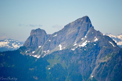
White Chuck Mountain/Northwest Route
A scramble with several exposed sections and a short downclimb in the North Cascades near Darrington. Enjoy views of Glacier Peak and the surrounding area.
Getting there
From Darrington, drive south on Mountain Loop Highway to N Sauk River Rd. Turn right on to Forest Road 22 which eventually becomes Forest Road 24. Turn right onto Forest Road 2430, drive on it briefly, bear left at the fork onto Forest Road 2435. Drive to road's end and trailhead. This is labeled on Google Maps "White Chuck Mountain Trailhead."
notes
- The road is extremely narrow with many potholes. High clearance, 4WD/AWD vehicles are highly recommended.
- There is very little room for vehicles at the trailhead, so carpooling is highly recommended.
Approach & Ascent
From the end of the road, follow an easy trail for ~1.25 miles, passing south of the northwest summit. Here the path begins climbing more steadily. Follow the boot path up the gully between the northwest and main summits. A ledge system leads out of the gully and across some slabs to climber's right, where the boot path is regained. There is a short section of exposed, down-sloping slabs that should not be attempted when wet. Follow the boot path to a notch just before the main summit. While exposed, the 15-foot downclimb is Class 3 and leads to another boot path that leads to the summit. To descend, reverse the ascent route.
- Suitable Activities: Scrambling
- Seasons: June, July, August, September
- Weather: View weather forecast
- Difficulty: Strenuous 2, Technical 4
- 6,989 ft
-
Land Manager:
Mount Baker-Snoqualmie National Forest
Darrington Ranger District (MBSNF)
- Parking Permit Required: Northwest Forest Pass
- Recommended Party Size: 12
- Maximum Party Size: 12
- Maximum Route/Place Capacity: 12
- USGS Sloan Peak
- USGS White Chuck Mtn
- Green Trails Mountain Loop Highway No. 111SX
There are no resources for this route/place. Log in and send us updates, images, or resources.
