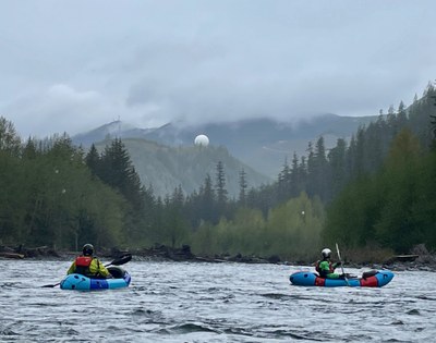
White River: Middle Reach
An exciting class II+/III- reach featuring gravel bar rapids interspersed with boulders. Seasonal flooding creates the ever present danger of river-spanning strainers as the glacial melt from Mt. Rainier drains down its mighty slopes.
The White River drains the eastern and northern flanks of Mt. Rainier. It is fed by the Winthrop, Fryingpan and White Glaciers and behaves according to the melting of the glaciers. This is a good entry into class III boating. There are no obvious, big class III ledges or technical drops.
FLOW
- NOAA Gauge: White River Below Clearwater River NR Buckley , WA- 12097850
- 1,000 - 3,000 CFS: runnable
- 3,000 - 4,000 CFS: pushy runnable
- Gradient: 44 fpm
PUT-IN
- Crystal River Ranch Rd Bridge: From Greenwater, head south on Highway 410 for 3.5 miles and make a right onto Crystal River Ranch Rd E. The bridge over the White River is immediately in view. There is parking for several vehicles on either side of the road before the bridge. Walk across the bridge and there is a use trail on the left down to a small lagoon for easy access.
TAKE-OUT
- Hwy 410 Mile Marker 38.3: 4.7 miles east of Greenwater there is a pull out on the south side of the highway that can accommodate about 10 vehicles. There is a short steep path down to the water and a nice eddy.
ON THE RIVER
From the put in to the confluence with the West Fork the river is narrow and fast. Huckleberry Rapid comes at 0.7 miles below the bridge, just above the confluence. Although it is not very technical it may push class III at higher flows. Below the confluence the river widens and is fairly active and braided. Constant vigilance for riverwide strainers is warranted. Past Greenwater the character changes as the river turns west, widens out, and winds its way down a wide river valley. On this section it is punctuated by occasional exciting wave trains and some braiding.
NOTES
- Beware of ever changing wood hazards and the need to portage., especially above blind corners.
- Watch for gravel bars and pay attention to finding the deepest channel down the braided sections.
- Water may be turbid from the glaciers on Mount Rainier making it hard to see obstacles below the water.
- Learn more on American Whitewater's White - West Fork to Bridge Camp (Middle) web page.
- Suitable Activities: Packrafting
- Seasons: Year-round
- Weather: View weather forecast
- Difficulty: Class II+ River, Class III River
- Length: 9.5 mi
- Land Manager: Land Manager Varies
- Parking Permit Required: see Land Manager
- Recommended Party Size: 6
- Maximum Party Size: 12
- Maximum Route/Place Capacity: 12
This is a list of titles that represent the variations of trips you can take at this route/place. This includes side trips, extensions and peak combinations. Not seeing a title that fits your trip? Log in and send us updates, images, or resources.
- White River: West Fork to Bridge Camp (Middle)
There are no resources for this route/place. Log in and send us updates, images, or resources.
