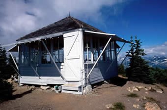
Winchester Mountain
This relatively short but steep trail leads to a lookout shelter with panoramic views within the Mount Baker Wilderness. Steep snow slopes in early summer followed by a profusion of berries along the trail make this trail better suited for fall hiking. It's 3.5 miles and 1,320 feet of elevation gain.
getting there
From Glacier, Washington travel east on Mount Baker Highway, SR-542. Twelve miles from the Glacier Public Service Center, turn left on Twin Lakes Road (Forest Service Road 3065). The road is located at the east end of the Department of Transportation's Shuksan maintenance facility. After 4.5 miles, reach the Tomyhoi Lake/Yellow Aster Butte Trailhead. The road beyond this point is narrow, with few pullouts, and is not maintained for passenger vehicles. During summer there may be mining truck traffic traveling on the road.
High clearance vehicles can negotiate the remaining two miles to Twin Lakes. Four-wheel drive is not necessary, but helpful. Check with the ranger station for road conditions before heading out. Twin Lakes Trailhead is located 6.5 miles from the highway between the two lakes. If you cant make it to Twin Lakes in your vehicle, you can park lower at the Tomyhoi trailhead, then hike up to Twin Lakes.
on the trail
From Twin Lakes, follow the Winchester Mountain Trail (No. 685) north-northwest. Encounter the High Pass Trail (No. 676) junction a half mile from the trailhead. Stay left to continue to the Winchester Lookout. Follow switchbacks upward through heather, flowers, berries and occasional small trees until reaching the summit at 6,521 ft.
notes
- The lookout building, built in 1935, is no longer used by the Forest Service for fire detection. A volunteer group now maintains the lookout and it is open to the public on a first-come first-serve basis.
- Carry drinking water, as there is none available at the lookout.
- Steep, exposed snow fields can linger into August. Hikers need an ice axe and experience traveling on snow to reach the lookout before the snow melts.
- Suitable Activities: Day Hiking
- Seasons: July, August, September, October
- Weather: View weather forecast
- Difficulty: Easy/Moderate
- Length: 3.5 mi
- Elevation Gain: 1,320 ft
- 6,521 ft
-
Land Manager:
Mount Baker-Snoqualmie National Forest
Mount Baker Wilderness, Mount Baker Ranger District (MBSNF)
- Parking Permit Required: Northwest Forest Pass
- Recommended Party Size: 12
- Maximum Party Size: 12
- Maximum Route/Place Capacity: 12
- Green Trails Mt Shuksan No. 14
- USGS Mt Larrabee
- Green Trails Mount Baker Wilderness Climbing No. 13SX
There are no resources for this route/place. Log in and send us updates, images, or resources.
