Trip Report
Alpine Scramble - Gray Wolf Ridge—Mount Deception—Royal Basin Traverse
A very strenuous but gorgeous, immersive, and varied alpine traverse to areas seldom visited by other humans. A trip with the flavor of a Bailey Range - Olympus traverse, but much shorter at 3 days, that included stunning vistas from Gray Wolf Ridge, a challenging but relatively low hazard ascent of Mt Deception (2nd highest peak in the Olympics), and a downhill visit (the best kind ;) of the majestic Royal Basin on our return to civilization.
- Sat, Jul 28, 2018 — Mon, Jul 30, 2018
- Alpine Scramble - Baldy—Gray Wolf Ridge—Mount Deception Traverse
- Baldy & Tyler Peak
- Scrambling
- Successful
-

- Road suitable for all vehicles
-
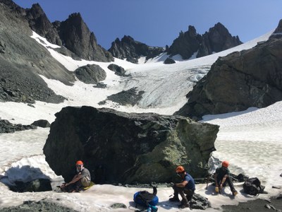
Other than a few isolated patches, the only snow encountered was the stagnant glacier/adjacent snowfields on the northern aspect of Mt Deception, and in Surprise Basin between Mt Clark and Mt Johnson. Crampons were mandatory for patches of ice on the Deception Glacier, and for the steep parts of Surprise Basin (just below the SE side of Surprise Col). With recent warm temperatures, plus no snow or water expected before our 1st night campsite (the tarn ~0.5 mile N of Mt Walkinshaw), we reduced our elevation gain by ~700 feet with a start from the trailhead for the Upper Maynard Burn Way Trail (described as the end of FS Road 2860-120 in the Olympic Mountains Trail Guide). This adjustment added ~400 feet of gain on our last day (our easiest day) via the Lower Maynard Burn Way Trail.
Our 2nd night’s campsite was changed to the tarn ~0.9 mile WNW of Mt Clark instead of our original plan for the tarn ~1 mile ENE of Gray Wolf Pass (a tarn that is now completely dry). This change was also dictated by the steep, non-trivial ice and snow on the northern aspect of Pt 7070 (our original exit route). Both of these discoveries were made on the morning of our 2nd day from a vantage point on the ridge ~0.3 mile NW of Mt Walkinshaw. As these conditions are likely to remain for future trips, I will shortly incorporate these changes into the existing route/place for this trip.
Other than the morning of the 1st day (Upper Maynard Burn Way Trail), and the afternoon of our last day (Royal Basin Trail), we saw no other humans the entire trip (although we did have a few trouble free visits from a solitary Mountain Goat at our 1st night’s camp before sunset).
On our 1st day an early ferry and an 8am start time gave us most of our elevation gain in the shade, with warm temperatures that became cooler with afternoon clouds and breezes. Photos starting with this day can be seen here. Although we mainly followed the ridge crest, for our ascent of the southern summit of Gray Wolf Ridge (elevation 7076 feet), we avoided steeper terrain by traversing west at ~6500 feet elevation, and then ascended its NW aspect. The traverse (at an elevation of ~5900 ft) of the ridgelet just east of our camping tarn gave us a last challenge at the end of a long day which totaled ~6000 feet of gain, ~10 miles, and 8.5 hours.
Our 2nd day involved a key traverse at ~5700 feet (using a game trails) to cross the ridge crest NNW of Mt Walkinshaw, traversed a bit, then ascended to ~6500 feet. Photos showing this key traverse can be seen here. After a change in plans (covered under Route Conditions), we descended through talus, scree, alpine trees/brush to an elevation of ~5600 feet, then traversed south to reach a beautiful stream surrounded by lush alpine meadows. We followed these meadows to reach a small ridgelet that afforded an easy ascent to our 2nd night campsite, a tarn below the ridge crest at ~6100 feet. Time from our prior night’s camp to this camp was 4.5 hours. After converting to day packs we crossed the ridge, traversed at ~6300 feet (to avoid excessive brush), then descended/traversed into the basin NW of Mt Deception to an elevation of ~5500 feet (a spot ~1 mile NW of Mt Deception). Photos starting from this spot that show the undulating and interesting (but relatively low hazard) ascent to the summit of Mt Deception via its NW aspect can be seen here. From the summit we retraced our route, which included several shade/water breaks as we ascended the final 800 feet (in a hot afternoon sun) back to camp. The day totaled ~6000 feet of gain, ~10 miles, and 12 hours (4.5 hours with overnight packs to our 2nd night camp, 4 hours to the summit, and 3.5 hours back to camp).
Our 3rd day started by descending our prior day’s route to the NW to reach the lush meadows/stream at ~5600 feet. Photos starting with this day can be seen here. From here we ascended SE (in very enjoyable shade) through meadows, boulders, loose talus/scree (some of the 3 steps forward, 2 steps back variety) to reach Surprise Col (at ~7000 feet) and our route back to Royal Basin through Surprise Basin. We resumed trail travel in upper Royal Basin, along with the company of other humans. We enjoyed our leisurely hike through Royal Basin (Royal Lake, Shelter Rock), but the final ~400 feet of elevation gain on the Lower Maynard Way Trail back to our cars, less so. The day totaled ~2000 feet of gain, ~10 miles, and ~9 hours.
One of the most enjoyable trips of my life, with a total of ~14,000 feet gain, ~30 miles, spread over three days with respective travel time of 8.5 hours, 12 hours (7.5 hours with day packs), and 9 hours. Photos from the entire trip can be seen here.
 Dave Morgan