Trip Report
Alpine Scramble - Petunia Peaks
Scenic and fun scramble in the NE corner of the Olympics. Originally booked as an Adams trip for students, the trip was rerouted to N. Petunia due to poor weather on Adams.
- Sat, Jun 17, 2023
- Alpine Scramble - Petunia Peaks
- Petunia Peaks
- Scrambling
- Successful
-

- Road suitable for all vehicles
-
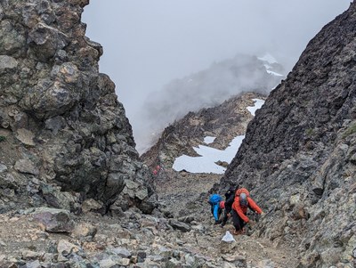
Road to Upper Dungeness TH is suitable for all vehicles. Summit gully is a bowling alley. I would not exceed a party of five in the gully with the party traveling in two groups; one moving while the other shelters in an alcove.
Overall trip specs 12 miles and 4.7k ft gain (it's more challenging than it appears on paper).
The first 3.5 miles are a mellow leg warm up to a nice camping spot across from Camp Handy. From there the trip ascends the north bank of a steep gully for 2.8 k ft in 1.7 miles. About 0.2 miles up the slope a 0.5 mile stretch of the trail is very steep with a few no fall areas and a short low class 3 rock section with lots of hand holds (as a group we slowed our descent through this section to minimize possible slips, trip and falls). The top of this section is followed by a short blow down area. The trail meets the stream above that at appx halfway to the lake.
We had a nice lunch at the lake and then proceeded up to summit. The snow slope past the ridge between the Petunias made for easy travel with crampons and ice axes to the base of the slope leading up to the summit gully. Having a party of 9 we split into groups of 5 and 4. The 2nd group waited at the top of the snow slope out of rockfall range for the 1st party to summit. Then the 1st party waited at the summit for the 2nd party to reach the summit. After enjoying the airy clouds blowing by the summit as a group for 15-minutes, we descended in a similar fashion.
The trip was moderately paced and took 12.5 hrs with short brakes going both ways at the river camp, stream rest area halfway to the lake and at the lake.
 Nathan Starr