Trip Report
Backpack - Packwood Lake
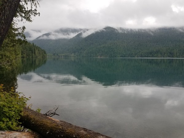
A relatively easy, peaceful backpack trip to a beautiful, clear alpine lake.
- Sat, Jul 6, 2019 — Sun, Jul 7, 2019
- Backpack - Packwood Lake
- Packwood Lake
- Backpacking
- Successful
-

- Road suitable for all vehicles
-
Both trails #78 and #74 are in great condition. Bugs were not a problem on the hike to camp or at camp. There were a few places on the hike out when we stopped on the #74 trail where they were present and bothersome.

We arrived at the trailhead on Saturday morning of a holiday weekend at about 9am. We had no difficulty finding parking for four vehicles. There is a pit toilet in the parking lot. After introductions and the trailhead briefing, we set out on trail #78. The trail winds through a lush, old-growth forest and has a very gradual 1,000' elevation gain over four miles. It is in great condition. We crossed paths with several groups of backpackers who had finished their trips and were heading back to the trailhead. After hiking less than 2.5 hours, we arrived at the lake where we paused for lunch.
There are several rather large group campsites spread along the east side of the lake on Trail #78, then #81. There were a few open campsites that had space for all six of our tents. We selected one that was about midway along the lake. It was a little more than a mile from where we had lunch near the old ranger station and footbridge.
The campsites are far enough apart that about the only time you realize someone else is at the lake is when a hiker/backpacker walks past your camp along the trail. Most of the camps are far enough away from the trail that you barely even notice the hikers. Note: Shortly after the trail transitions to #81, you are entering the Goat Rocks Wilderness where you are required to complete a Wilderness Permit at the trail box.)
After setting up camp, we went on a four-mile round trip hike southeast along Trail #81. We went as far as a stream that did not have a bridge. We took the opportunity to discuss stream crossings, the associated dangers and strategies for finding ways to cross. We talked to a few hikers who crossed it. They said the hikers in their group with good balance and trekking poles managed to cross without getting their feet wet. The hikers without poles ended up with at least one wet foot.
Our camp was home to a chipmunk or two who seem to be acclimated to humans. They were occasionally visible, but weren't pesky or bothersome. Overnight, one of them scrounged around inside the tent vestibule on the backpack of one of our campers despite that fact that there wasn't any food in his tent. We stored our food in critter-proof canisters and kept them away from our tents. I watched one chipmunk approach my canister, sniff around it for a minute, then scamper away.
There were a few raindrops overnight, but no accumulation. We awoke to a quiet, serene morning with the lake reflecting the surrounding mountains. Cloud cover was low with an occasional ray of sun.
We packed camp and left just before 10:00am. After arriving at the junction of Trails #78 and #74 (near the historic ranger cabin just past the footbridge), we talked about which trail we wanted to take to the trailhead. Both trails terminate there. Trail #74 is an old road that was built for a hydro-electric project at the lake. ATVs, motorcycles and mountain bikes are permitted to travel the trail. We were a bit anxious about hiking on a road/trail with possible head-on, fast-moving ATVs or motorcycles. After some discussion, we decided to take the #74. Fortunately, we didn't encounter any motorized vehicles, only a family of three who were day-hiking to the lake. Note: There are several places where the trail narrows at blind corners where encountering a fast-moving ATV or motorcycle can be potentially dangerous.
There are two places along the #74 trail where it divides. Both forks have signs that state hikers to the right. We stopped at each fork and reviewed our maps. The divided trail at the first fork converges a short distance later. After reviewing our maps at the second fork, we decided that we didn't trust the sign at the second fork. We trusted our maps, and we chose the left fork.
There are a few overlooks along the trail where I've read there are stunning views. Because of the cloud cover we were only able to see into the valley and some of the mountains, like Dixon Mountain, on the other side.
When you see the green gate near the end of the #74 trail, the parking lot at the trailhead is on your left up the hill above the boulders. Just past the green gate we noticed that there is a small switchback trail leading up to the parking lot. It terminates at the restroom in the parking lot. If you miss the little trail, you can continue a short distance to the paved road. Make a left and you will walk right into the parking lot.
The #74 trail is in good condition and easy to travel. Our GPS devices recorded that the distance from our camp to the trailhead was shorter along the #74 trail than the #78 trail by about a mile.
We were back at our cars in less than 2.5 hours. After minimal discussion, we decided to stop by the Blue Spruce Saloon in Packwood for a most excellent burger and microbrew - the perfect ending to a great weekend. Good times.
 Bob McFarland