Trip Report
Backpack the Peaks, Lakes and Glaciers of Aysén, Patagonia
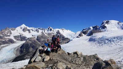
This trek was a totally custom, off-trail adventure involving a jetboat ride up and down the narrow Leones river, a zodiac ride along a lake filled with iceburgs and across another lake to the toe of a large glacier, crossing multiple rushing rivers by pulling oneself and pack across several Tyrolian wires on a harness, and stunning trekking across high alpine terrain past lakes and moraine to a camp on a pass looking directly across to Monte San Valentin, the highest peak in Chilean Patagonia, and a very challenging day-walk up an unnamed peak to a vantage point in the middle of several glaciers flowing down from the North Patagonian Icefield. Participants carried overnight gear and food for 5 nights/6 days.
- Sun, Mar 3, 2019 — Tue, Mar 12, 2019
- Backpack Remote Central Chilean Patagonia to Cerro Castillo and the North Patagonian Icefield
- Backpacking & Global Adventures
- Successful
-

- Road rough but passable
-
Completing this trip involved all kinds of custom conveyances including a jetboat ride 20 miles up a narrow wild river, tyrolean wires, zodiacs and walking - sometimes on and sometimes off trail - on often very rugged terrain. We chose the best season for good weather and succeeded with most days being clear and only one day of rain, but this trail could be quite hypothermic and treacherous in extended days of rain due to hours of walking in explosed high country, rugged moraine and scree, and a very steep muddy descent through forest.
This trek was a totally custom, off-trail adventure developed with the Terra Luna lodge in Puerto Guadal. The lodge provided essential jetboat, zodiac and helicopter support services as well as expert local guides who were the only people who had done the entire trail system before us. It was absolutely stunning and unforgettable – in addition to a jetboat ride up and down the narrow Leones river, a zodiac ride along a lake filled with iceburgs and across another lake to the toe of a large glacier, and crossing multiple rushing rivers by pulling oneself and pack across several Tyrolian wires on a harness, the experience included a gorgeous walk across high alpine terrain past lakes and moraine to a camp on a pass looking directly across to Monte San Valentin, the highest peak in Chilean Patagonia, and a very challenging day-walk up an unnamed peak (our outfitter had named it Mount Putagonia) to a vantage point in the middle of several glaciers flowing down from the North Patagonian Icefield.
Participants on this trek must be mentally and physically prepared for difficult conditions and steep descents and ascents on what can be very rocky and muddy-slippery routes, mostly off trail or on unimproved ‘trail’, and in often cold and wet weather. Participants must be fit and experienced to carry all their overnight gear and food for 5 nights/6 days. Our longest day was 9 miles and 3500’ of gain.
We worked through Terra Luna Lodge to arrange for guides, food and transport for the trek, and included two nights at the gorgeous and comfortable Terra Luna Lodge on Lago General Carrera http://terraluna.cl/en/terra-luna-patagonia/. The trip can be arranged by contacting Terra Luna lodge which operates parts of this as a commercial day trip and also arranges custom trips. (I don’t know of any other way that you could do this specific route which isn’t accessible except from a starting point high up Rio Leones.) Be forewarned that the proprietor of Terra Luna is a frenetic entrepreneur who can put together just about any trip you request but he is very last minute on the details and you really need to insist on detailed advance communications because he could set you up on a route that is too technical for your group and you might not find out until you get to the rock face or steep glacier that your participants aren’t capable of doing. We also found afterwards that the guides and support crew we had (all fantastic!) were all arranged at the last minute, and I had to push and push to get the food arrangements settled with enough lead time to work the bugs out. Nonetheless, when we needed something to be ready it was ready, and the trip went mostly without a hitch.
Transportation for both treks requires flying into the Balmaceda airport and transferring to Puerto Guadal. Public transport comes from the town of Coyhaique which is about an hour north of Balmaceda, and takes 6-7 hours to get to Guadal (mostly on the washboarded dirt Carretera Austral) by a bus that operates 6 days a week, or by taxi or private transport which takes about 7 hours.
We spent the night of our arrival in Coyhaique so that anyone with delayed bags could have a bit of time for them to catch up. Luckily that wasn’t an issue this time.
We had mostly very good weather, very lucky in this region which is notoriously wet and stormy even in high summer. This route could be VERY treacherous and hypothermic in wet weather.
See the following google photos album for pictures from the trek: https://photos.app.goo.gl/44pmvTfwLGwRpWM97
For more details on the route and logistics contact the trip leader, Cheryl Talbert, at cascadehiker@earthlink.net.
 Cheryl Talbert