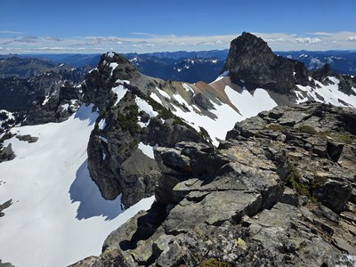
Trip Report
Basic Alpine Climb - Banshee Peak & Cowlitz Chimneys
Beautiful area, climbed Banshee Peak and Cowlitz Main Chimney
- Fri, Jun 28, 2024
- Basic Alpine Climb - Banshee Peak & Cowlitz Chimneys
- Banshee Peak & Cowlitz Chimneys
- Climbing
- Successful
-

- Road suitable for all vehicles
-
Creek crossings are doable but may be running higher in the afternoon/evening on warm days
- Met at Summerland Trailhead at 6am and started hiking at 6:30
- Uneventful hike to Fryingpan Creek crossing - the creek is no longer running under the bridge but next to it. There are three stacked very small logs which provide a way across. A few minor stream crossings before that.
- Shortly after the creek crossing (at about 5500’) snow starts consistently. A few people had trail runners and switched to boots and all of us put on gaiters. Trail runners were cached higher up at Summerland shelter.
- It’s easy to miss the first switchback on trail and continue too far and then go up a snow finger next to a creek, so keep an eye on the map here to avoid bushwhacking
- The last running water that the trail crosses is at 6180’
- We elected to go up Panhandle Gap instead of the “shortcut” east at the 6740’ saddle NE of Panhandle Gap, since this shortcut leads to steep sidehilling. Getting up to Panhandle Gap was steep but the snow was good and runout was fine. If icy, crampons/ice axe may be advised.
- From Panhandle Gap there is a trail that leads east to the 6640’ saddle (partially snow covered at the moment)
- From the saddle to Banshee summit is a walkup on snow/heather. It’s appealing to stay climber’s left near the edge of the rising plateau but going slightly right is a more direct line to the summit (see the map) and avoids cornices
- Reached Banshee summit after 5.5 hours (12:00) and took a half hour lunch. No summit register.
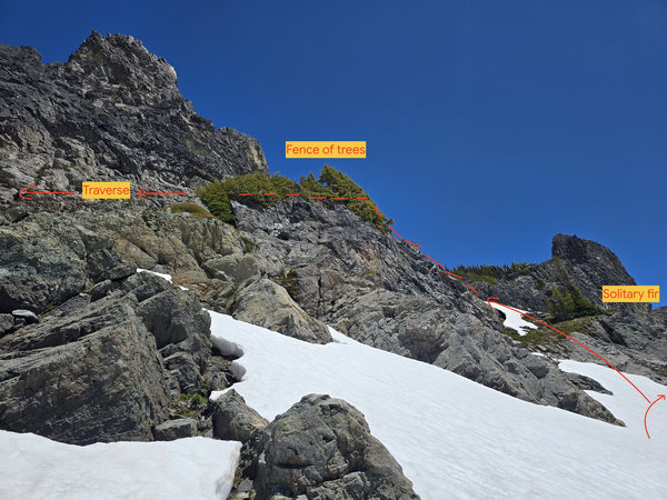
- Descended the SE slope of Banshee and arced around the Cowlitz bowl, reaching the solitary fir and fence of trees 1 hour and 20 minutes later (14:00) and put on harnesses here. We brought ice axes, poles, gaiters with us but they were not necessary above this point.
- There is a good overview picture at Eric’s Base Camp: https://www.ericsbasecamp.net/trips/CowlitzChimney/CowlitzChimney.htm
- It’s easiest to go climber’s right of the fence of trees and traverse immediately above them
- From here, using radios was extremely helpful, because the two ends of the team are not in eyesight or earshot.
- When the trees end, the traverse starts. Slung a tree for the anchor and fixed one end of the 30m glacier rope here.
- The first half of the traverse is a nice ramp. The second half has some easy class 3 moves (but is exposed). Used one small nut at the halfway mark.
- Once you reach the trees, you can veggie belay up them to a platform where there is a tree. Fixed the other end of the rope here and had everyone prusik across the handline, and belayed the last person across.
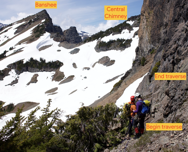
- From the platform, the chockstone gully is a few horizontal steps away. Everything above the chockstone is very loose but there are good hand and footholds on climber’s left of the chockstone. You can put a nut at the base of the chockstone chimney.
- Fixed another 30m rope at the platform tree (while others were traversing first handline) and fixed the other end at a small tree a little bit above the chockstone (many of the larger trees in this area are dead). Again, belayed the last person up.
- Once above the chockstone, it’s class 2 but extremely loose, necessitating people climbing one at a time
- Note that the rappel stations mentioned in other trip reports was nowhere to be found
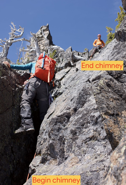
- There is a path full of very loose scree that leads up from the chockstone which reaches an opening. We later found a less loose path through the trees climber’s left of the loose path.
- From the top of the scree path, bear up and left on loose scree until reaching a ridge overlooking the east (Double Peak, etc)
- Followed the loose ridgeline to the area below the summit headwall and identified the notch. There are descriptions that describe the ascent up the gully leading to the notch as class 2. There appears to be no class 2 gully, instead it has a couple of class 3 moves but is loose, and all recent tracks on Peakbagger have gone the same way. We spent some time trying to seek out the mythical class 2 gully. There is plenty of loose rock in this gully and above it. Climbing gets significantly easier the closer you get to the summit.
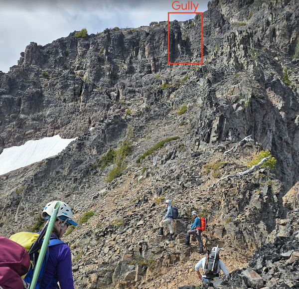
- Getting into the gully is a bit tricky from directly below but reaching the base of it from climber’s right was easier
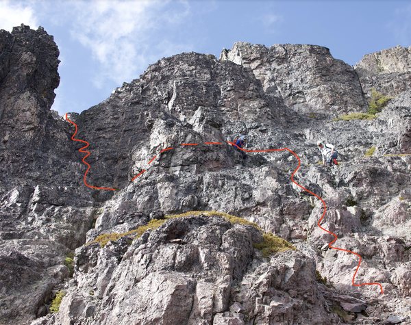
- From the top of the gully, the summit is visible and took another 5-10 minutes. We arrived at the summit 2.5 hours after the beginning of the traverse (16:30) but didn’t spend much time there. There is a summit register there.
- I explored an alternative gully for the descent (west of the regular gully) and found it to be similar to the regular one with perhaps a more difficult exit at the bottom, so we stuck to the known quantity. Some may want a belay down the gully and there are some small trees on top for a slung anchor.
- Descended to the top of the chockstone and fixed one end of the 30m rope to the same trees for an anchor and had everyone single-strand rappel down to the snow from here (just reached). I broke down the anchor and downclimbed the chockstone chimney and reversed the traverse (so there is still no rappel anchor at present). I reached the bottom of Cowlitz Main 2 hours and 45 minutes after the summit (19:15) while the rest of the group began the return.
- Reascended almost to the summit of Banshee (staying lower can result in steeper slopes or cliffing out). Reached this point 45 minutes later (20:00)
- From this point, it’s almost all downhill except for the ascent back up to Panhandle Gap
- The creek at 6180’ was running a bit higher and had to go around it on a snowbridge. Filtered water here.
- Reached the switchbacks below Summerland shelter when it got dark
- Fortunately, the Fryingpan Creek crossing from the morning was still passable with the three thin logs.
- Reached the trailhead 3 hours 45 minutes after Banshee summit area (0:00) - total 17 hours 15 minutes
- We had intended to also go up Central Cowlitz Chimney but did not have time. However, there are trip reports indicating that groups have summited all three in “14+ hours”
- Notably, movement on Cowlitz Main Chimney was slowed by the need to manage loose rock & rockfall, meaning that the group was sometimes at a standstill while one or a few people were able to move. Having a smaller group would speed things up in this regard.
- Gear used: ice axe, poles, helmet, harness, rock gear, radios
- Gear brought but not used: crampons
- See also trip report from Sharon Carlson
 Dennis Kiilerich