
Trip Report
Basic Alpine Climb - The Brothers/South Couloir
Great weather, excellent conditions, but needed an early start to "Catch it while it's cold" and avoid more dangerous conditions.
- Sat, May 27, 2017 — Sun, May 28, 2017
- Basic Alpine Climb - The Brothers/South Couloir
- The Brothers/South Couloir
- Climbing
- Successful
-

- Road suitable for all vehicles
-
The bridge across the creek on the north end of Lena Lake was damaged and cut into a few pieces by the Forest Service. We had brought a couple large garbage bags to put over our feet in case we needed to ford, but found that we could cross it carefully.
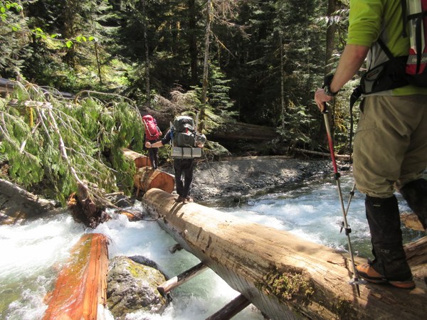
About 3/4 mile up the Valley of the Silent Men (East Fork Lena Creek), the trail gets washed over by the creek itself and pretty much disappears. There is some flagging that is hard to follow. When you get to a set of large rocks where the trail disappears and the creek pushes you to the right side of the hill, go to the right over the boulders. You can stay to the right, up on the hill, for several hundred meters, or try to find the summer trail between the creek channels. I knew the "summer route" through the channels, so I went around the boulders, then left across one channel, upstream on a boot path across a little island, then rightward to cross the channel again and then up onto the mossy rocks on the right hill. Then stay up on the mossy rocks for another hundred meters to regain the boot path where it departs the creek on the right hand side again, soon after a section where a large part of the creek was up against the right side. If in doubt, stay up on the mossy rocks, but periodically drop down by the creek and see if you come upon the boot path.
The last 1.5 miles to climbers camp is on decent trail, except one spot where you have to cross the creek again on downed trees or a damaged bridge.
See the trip report for the conditions on the climb.
I took a group of 9 who had always wanted to climb this route. We went on Memorial Day Weekend Sat/Sun.
WEATHER: Very warm -- 80's in the valley, 60's at the summit, no freezing overnight, but clear skies to help the evaporative cooling. The last snowstorm was 1.5 weeks ago. The avalanche update told us to watch for loose wet slides and cornices, along with possible weakening of deeper layers. The clear sky would help the snow to solidify overnight.
GEAR: We planned it as three glacier style rope teams (3 in a team), so we brought a glacier rope and two pickets per team. There hadn't been any recent trip reports, so we didn't know what to expect. Each individual had helmet, harness, belay device, prusik, a few runners and 'biners, crampons, and ice axe. -- We ended up using one rope as a handline with prusiks because we got off route in the wrong gully once. We did not need the crampons. But we had enough gear to keep ourselves out of trouble without being too heavy.
DAY 1: On Saturday, we met at the Lena Lake trailhead at 9:30 and it was already 90% full. Some of us took the ferry from Edmonds, while others came from the south on Hwy 101. The trail to Lena Lake was an broadway of switchbacks and we hiked along with many other hikers out for the day or the weekend. We left almost all of them behind as we turned around the north shore of Lena Lake into the Valley of the Silent Men. As mentioned above, the bridge on the north side of Lena Lake is damaged, and the Brothers trail up the East Fork Lena Creek valley has a section that is difficult to navigate. We got into base camp about 3 pm. There were open tent spots on the ground, or snow-covered tent spots all over the place. The bottom of the valley was a variety of tent sites on dirt or snow, with 1-3' of snow in various spots. We camped at the intersection of the East Fork Lena Creek, and the creek that we would climb (unnamed). There are plenty of places to camp along either creek, as well as further up the slope towards the climb. And, there was a huge log on which to cross the creek into camp. We ate dinner, and then a few of us scouted the route across the snow and up onto the forested slope to find the boot path. The snow cover disappeared as we got up on the hill, so we finally found the boot path where this GPS shows the track departing from the creek ( I got a couple tracks from Gaia GPS Online). We headed to bed about 6:00-6:30 for an early start on Sunday.
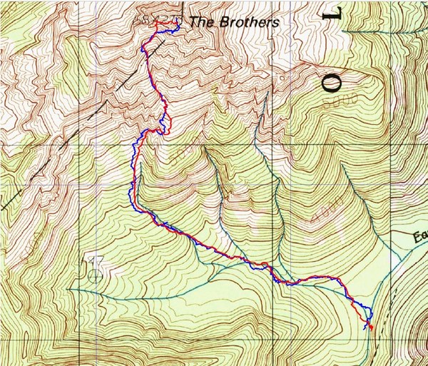
DAY 2: We left camp at 4:10 to avoid the hot sun baking on the snow fields both up and down the route. In the dark, it was harder to find the boot path across the snow-covered valley floor, but it helped to have scouted the night before. We cruised up the boot path as the sky gradually lightened and reached the open avalanche slope just as it got light enough to see the southern slopes of the mountain. We crossed that avalanche slope on snow and got onto the ridge of burned out trees that we needed to cross. We climbed over sticks and logs for quite a ways. Don't do that. Just cross the burned out ridge and get into the next creek that takes you up to the South Couloir. The logs are not fun to cross. I heard a few cuss words there.
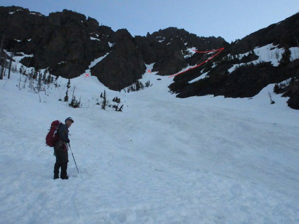
The south couloir was a nice wide snow-covered slope with many "possible" ways to go. I think the route varies between early and late season. In this picture, the better route headed up to the right, onto the long ridge on the right hand side. That will take you from about 5,200' to 5,300 where you could catch the ridge toward the NW into a narrower gully. Unfortunately, we took the gully left of that marked with an "x" because some other beta said "take the left gully" and we saw two other teams up there. That took us up to wet ledges and we had to set a handline to get over the worst section and reduce our risk. Oh well. On the descent, we came down the ridge to the right and it was so much better
 We joined several other climbing parties above those rocks, and climbed up the NW gully along with them. The route was fairly straightforward after that, and the snow conditions were great for just kick-stepping up the slope without crampons, ropes, or picketed protection. So we just followed kick-steps or made some of our own.
The NW facing gully took us from about 5,500 to about 6,200 feet, heading toward a saddle in the ridgeline. Before that saddle, we turned right into what I believe was the "hourglass". Although, there was so much snow, nothing looked like an hourglass. It was supposed to be at about 6,200 feet. Anyway, we headed to the right, around a big chunk of rock toward some spires on the right horizon, then to the left on an obvious snow filled slope.
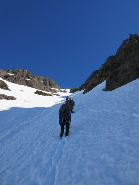
The image above shows the saddle. The image below shows the turn to the right toward spires, and then to the left again below the spires.
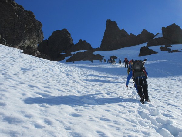
Beyond the spires, we were just a few hundred feet below the summit. The snow slope took us toward the ridgeline again. We checked over the ridgeline, and it was just steep rock and corniced with snow and not a good route. Just before that was a narrow cleft to the right that could be scrambled, but it contained a roped team on a guided trip, so we headed to a steep snow slope to the right of that. That took us into a wider gully that was very full of scree, but it also helped us bypass the rope teams in the little notch. We carefully ascended the scree in small groups until we were on clean rock and ledges to the summit.
Wow, there were probably 20-30 people on the summit including us. We spent only 10-15 minutes taking pictures and quickly enjoying views to the east, although it was a little hazy that way -- We could see Baker, Rainier, Adams, St. Helens, The Hood Canal and Puget Sound... Amazing! This peak has such great prominence. A private group of Mountaineers was attempting the North Brother to South Brother traverse, but we saw no sign of them. We did however, look over the traverse and felt that it looked rather "alpine", I'd say :-). We then we decided to be the first to descend back to the base of the little notch rather than sitting on the summit for an hour (which we could have easily done in the 60 degree weather).
We ate lunch at the base of the summit block, and enjoyed the views of the Olympics to the south, west and north. That direction was clear and unhazy. To the SW, we had great views of peaks like Washington, Eleanor, Jefferson, and Pershing, along with Lincoln and Cruiser. Toward the NW, Olympus was nice and clear.
After lunch, we descended our climbing route, but took the much better ridgeline down to 5300'. It then turned right to another snow slope onto the lower part of the south couloir snowfield. We plunge stepped on great snow conditions all the way down beyond the ridge, to about 5,200', and only then did we feel comfortable to glissade another 500' to the burned out ridgeline where the snowfield ended at about 4,700'.
It took us 5.5 hours to climb -- 4:10 to 9:40. We were back at camp by 1:00 for a total climb time of 8.75 hours. We met a couple people back at camp who turned around at about 10:30 and 5,000' when they had seen a large chunk of snow fall off upper cliffs and drag down some loose wet snow into the lower couloir. I don't recall seeing any evidence of that, but we had definitely made a good choice to start very early on this very warm and sunny day. The small gullies showed evidence of some sluffing, but it didn't seem very recent. It's hard to tell when the snow melts so much in a single day. This picture of our glisade (we came from the right), shows one gully with some evidence of sluffage along with moats and such.
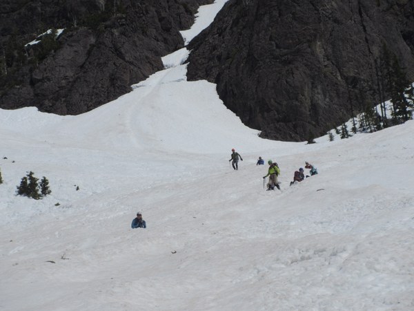
We spent about an hour packing up before hiking back to the cars. The East Fork Lena Creek was running even higher and we had to be even more careful crossing the damaged bridges and the washed out trail section in the middle of the valley. And, by the way, there are some lo-o-o-ong switchbacks on the lower part of the Lena Lake trail. We reached the cars about 5:30 p.m. I guess this climb covers almost 20 miles round trip, with over 6,000' of elevation gain in two days. My feet were pretty tired, but my mental health was very satisfied with a great alpine climb among wonderful people!
 Brian Starlin