Trip Report
Cathedral Peak & Amphitheater Mountain
A long, three day trip deep into the Pasayten Wilderness in the North Cascades. Climbed Remmel Mountain, Cathedral Peak, and Amphitheater Mountain.
- Mon, Jul 5, 2021 — Wed, Jul 7, 2021
- Cathedral Peak & Amphitheater Mountain
- Climbing & Scrambling
- Successful
-

- Road suitable for all vehicles

Remmel, Amphitheatre, and Cathedral are three Bulger peaks located deep in some of the most beautiful terrain in the Pasayten Wilderness. Although the mileage does add up, the scenery of the region and the challenge of Cathedral makes the trip worthwhile.
The road to Thirtymile Trailhead is well-maintained and has a lovely memorial for the lives lost in the 2001 fire. A Northwest Forest Pass is required to park in the lot.
Day 1:
After sleeping at the trailhead, we started off from Thirtymile Trailhead at about 6:45 am on July 5th. We hiked on the Chewuch Trail for roughly 12 miles, staying left at the major intersection with Tungsten Trail. We then turned left off the Chewuch Trail onto Four Point Lake Trail. Shortly after this turnoff there is a creek crossing. It would be straightforward to wade across if the water is low, but we instead wandered left along the bank to a collection of fallen logs that make a decent bridge. After 2 miles on the Four Point Lake Trail, we turned right to Four Point Lake.
The trails are in good condition despite their remote location (we actually encountered a trail maintenance crew on the Chewuch Trail and another crew right before our arrival at the lake). Total distance to the lake was roughly 14.5 miles, but, except for the last couple miles to the lake, the ascent was very modest (we only climbed about 3,000 ft vertical total). It took us about seven hours at a moderate pace and with a lengthy lunch break.
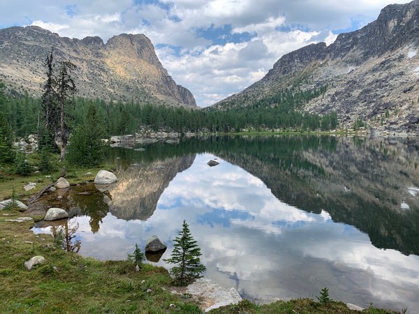
After dropping overnight packs at a camp spot along the lake, we took daypacks up Remmel Mountain. To do this, we hiked down from the lake to the intersection with Four Point Lake trail, at which point we turned right (onto the abandoned Coleman Ridge Trail as some maps identify it). At some point we left the Coleman Ridge Trail and turned up towards Remmel, following a boot path. We lost the boot path at some points in the brush or rocks, but as we continued making our way upwards, the trail was easy to pick back up. Once we ascended onto the southeast ridge on Remmel, we somehow lost this obvious trail and ended up scrambling straight up the boulder field slope to the summit. Although the elegant direct route we took works, following the trail might be more efficient. It is a superhighway of a trail, marked by cairns, that traverses across the southwest face of Remmel and then zig zags up to the summit. The trip was about 4.5 miles roundtrip with around 1,800 ft of elevation from the lake to summit. It should be noted that Four Point Lake was beautiful but had HORRIBLE mosquitoes and little flies. Make sure to bring protective layers, lots of bug repellent and a head net if possible.
Day 2:
In the morning, after packing up camp, we decided to travel cross country in order to cut off some mileage. We climbed over the pass at the northern end of Four Point Lake and descended until we crossed Remmel Creek and intersected Chewuch Trail. There was a lot of bushwhacking and stopping to check our GPS track, but we probably saved about 45-60 minutes (if you want to avoid the trouble of cross-country travel though, you could just follow Four Point Lake Trail back to the Chewuch Trail intersection and turn left onto Chewuch Trail). At the next intersection, we stayed on Chewuch Trail (the central, most prominent path). At the following intersection, we turned right onto Lesamiz Trail and followed it until it reached the Boundary Trail, which we turned right onto. Although we originally planned to camp at Upper Cathedral Lake, we ended up picking a place earlier along the Boundary Trail to try to avoid bugs.
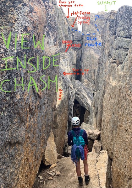
We dropped overnight bags there and continued along the Boundary Trail past Upper Cathedral Lake (which is gorgeous) to the base of Cathedral Peak. For equipment we brought a scramble rope, harnesses, belay devices, a few slings each, some carabiners, and our helmets (we also brought a small rack but didn’t use it). The vast majority of Cathedral involves gaining elevation on its southwest slope. We just aimed for the large square notch along the ridgeline. Once at the notch there was a faint booth path and cairns that led us towards the right. After scrambling up some blocky rock sections we were able to peer into the chasm for the first time.

At this point, we went a bit to climber’s left to a sloping rock slab that allowed us to descend into the chasm. Once in the chasm, we followed it and then transitioned onto the obvious narrow ramp on the left wall. After following the ramp for maybe 10 feet, we turned up to our left at the first opportunity after spotting a cairn. If you continue straight along the chasm, you run into a dead end that would require some very challenging, exposed scrambling. After scrambling up to our left, we turned right and followed the mountain around to an opening that led to a rock platform. At this point, we set up an anchor with our equipment. My climbing partner belayed me across a sloping boulder lodged into the chasm and then up part of the opposite side. From there I unroped and scrambled the last hundred or so feet to the summit, which is spacious and flat. I was unable to find a summit register so Cathedral may need a new one. My climbing partner did the same thing once I descended and was belayed back across the chasm.
After reading trip reports before the climb, we had originally looked for the “leap of faith” but were baffled as to where the leap would take place. The only two places of the chasm that would be feasible to jump across seemed pretty risky, especially given the remoteness of the peak. I would definitely recommend packing a scramble rope for safety. It would be a bummer to hike so many miles only to be turned back within sight of the summit. Overall, Cathedral is a super enjoyable puzzle of a climb with solid, quality rock and lots of fun class four scrambling.
Day 3:
We woke up the third morning and climbed Amphitheater Mountain from the west (the standard route). There is a boot path up most of it and the terrain is very gentle. We only ascended about 1,000 ft so roundtrip from the base of the mountain was a leisurely two hours at most. Amphitheater has a summit register but no writing utensil.
After descending back to camp, we were hit by a rainstorm and decided to retrace our steps and exit via the route we came (though we obviously just stayed on the Chewuch Trail this time instead of going cross country back to Four Point Lake). It was 19 miles out and took about 8 hours, so we had some very sore feet by the end. If you have time though, I recommend continuing the loop along the Boundary Trail over to Tungsten Mines, which is supposedly very cool. You can also climb Apex Mountain via that route, which gives you spectacular views back to Cathedral. It’s essentially the same mileage as the out-and-back route we did.
Doing the whole trip in three days was doable but tiring (it was about 55 miles total). So, if you can, taking your time and enjoying the wilderness might be nice.
 Scott Campbell