Trip Report
Day Hike - Lost Valley Loop
Good Winter hiking alternative, you share the trail with Mountain bikers.
- Fri, Dec 3, 2021
- Day Hike - Lost Valley Loop
- Lost Valley Loop
- Day Hiking
- Successful
-

- Road rough but passable
-
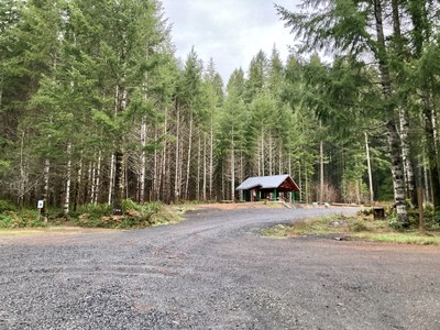
It is about 7 miles after the "Capitol Forest" sign comming from Olympia. Discover pass is needed. Falls creek trail head has a large parking lot, covered pavilion area and trail head restroom that was clean and stocked! Road has some pot holes, SUV or truck is recommended, not low clearence cars. Note snow is possible tomorrow, all this can change with weather.
This is was a good alternate Winter hike. Mostly forest, clear cut and some small bridge crossings. It had rained prior week but trail was not as muddy as I expected. Obvious drainage work was done probably by bikers. We hiked counter clockwise, the way down was very packed dirt ( due to mountain bikes), it would be awful if wet/slick so be prepared.
We saw a group of 5 Mountain bikers who passed us up and back otherwise no one else. They were very polite and considerate, we allowed them to pass and they appreciated it. Falls Creek trail head is AFTER the Falls creek campground, it is the launching point for many trails. Our leader wore some bright colors but saw no shooting signs. When you are near the Mima trail crossing you can hear the gun range that side of the mountain.
7.25 mile loop through clearcut, new plantings and trees. 920 FT , mostly gradual elevation gain per GAIA .
Trail could be muddy and slick in spots, some walking on a forest road. Parking area is large, has a 2 door rest room that was clean and well stocked. Road has pot holes and all vehicles could make it but better to have clearence or SUV. Dress in layers, one side of the mountain you circle was significantly colder.
 Terri Pressly