Trip Report
Gilbert Peak via Conrad and Meade Glaciers
A rarely done, adventurous route via 2 receding Glaciers to the highest peak in Goat Rocks Wilderness
- Wed, Jun 26, 2024
- Gilbert Peak/Conrad Glacier
- Climbing
- Successful
-

- Road suitable for all vehicles
-
if you’re planning on doing this in June during a weird-snow year, you need to be ok with the following: route-finding, variable conditions, steep snow slopes, bushwhacking through pine trees (in the snow), muddy bogs, loose talus fields, navigating stream crossings, carrying snowshoes unnecessarily, and either walking on rocks in crampons or incessantly putting on/removing said crampons.
(Curtis) Gilbert Peak via Conrad and Meade Glaciers, team of 6. A rarely-done, exploratory route. “Alternate” route via Conrad Glacier to upper mountain & summit is out right now. We crossed Conrad and went up Meade Glacier to access the summit.
Overview: Overnight trip: 26 miles RT, approx. 5800 elevation gain/loss. Brought and used: crampons/ice ax/glacier rope/harness/glacier gear/hiking poles/bug spray. Brought and didn't use: snowshoes. Tip: if you’re planning on doing this in June during a weird-snow year, you need to be ok with the following: route-finding, variable conditions, steep snow slopes, bushwhacking through pine trees (in the snow), muddy bogs, loose talus fields, navigating stream crossings, carrying snowshoes unnecessarily, and either walking on rocks in crampons or incessantly putting on/removing said crampons. That said, views are amazing from the top! And there was no one on our route!
Day 1: Started hiking around 12:15p from Conrad Meadows TH (road fine, can drive there). Short road walk to the gradually graded South Fork Tieton Trail, continued through a meadow until coming to a dilapidated bridge crossing a creek, take care when getting onto and crossing the bridge (fallen trees, loose/cracked boards/exposed nails) then headed up the trail following the river until turning right at a trail junction around 4.5 miles in. A few blowdowns to navigate around and inconsequential creek crossings via rock-log hopping along the way. Around 5100’ veer off the trail to the right. Many more blowdowns and some snow patches from here to 5700’. Followed GPS and portions of exposed trail to the ridge where we had a brief lunch sheltered in the trees (it was really windy). Stashed trailrunners and changed into boots w/gaiters @ 5900’ where snow began in earnest. Followed 6k’ contour line, descending about 200’ until hitting the first of 3 creek crossings. Couldn’t find a great spot to cross that wouldn’t require wading into swift-moving water so explored and found what turned out to be a solid snowbridge 200’ higher, above the waterfall. Stayed high on the other side and were able to avoid the second crossing via snow. A bit of bushwhacking and an additional (snow-covered) crossing of the 3rd creek led us to descend back to 5800’ on a moderately steep snow slope to regain the (boggy, wet, partially snow-covered) trail. Found a sheltered campsite in the trees at the end of the map-marked trail at around 5900’ (under the ‘ee’ in ‘Creek’ on the USFS map) out of the wind on dry ground by Conrad Creek. Tons of places to filter water. Day 1 Stats: 10.5 mi: 2650' 6:45 with lots of little breaks and route-finding.
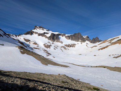
Day 2: Started hiking at 6:30a with crampons/ice axes/helmets on. Snow firm in shade, top layer soft with firm layer underneath in the sun. Traversed across snowfields and rock/heather benches to around 6400’ then dropped down a bit to stay on snow (ended up doing a mild bushwhack through a stand of pines in the snow) towards Barren Lake (6416). From there, headed up the snow slopes towards the notch between the Conrad and Meade Glaciers, crossing a few rock bands and avoiding others by dropping lower since we had no visual of what was on the other side of the rocks on the higher traverse (traversed high on the return). Skirted a few rock bands and roped up on the Conrad Glacier around 6900’. Went straight up the glacier to the saddle (notch) to access the Meade Glacier (7200’). Though we descended slightly, WSW, I suggest staying high (following our return track). Headed towards the Klickton Divide via steep snow slopes and began our crampon on/off game, removing them for the rocky ridge and putting them on again to cross a steep, firm snowslope below the summit to the west. A small rock step climbers left avoiding icy rocks put us on a talus field, followed by another short patch of snow directly below the summit pyramid. Removed crampons for the scramble to the summit where we had gorgeous views of Tahoma (Rainier), Pahto (Adams) and Loowit (St Helens)! Downclimbed and avoided the upper section of snow by descending via loose talus field back to the rock step (crampons on) where we traversed across the softening lower snow section back to the Klickton Divide (rocks-crampons off). Roped up and headed South down the ridge a bit before dropping to access the Meade. Headed back to saddle via a higher traverse, crossing above a rock moat then back down the Conrad Glacier. Unroped at 6900’ and kept high, hit more rocks (crampons off) and ended up a bit too high, having to descend a very loose talus field. Found our camp, packed up and left (no more crampons!!!) uneventfully following our exact track on the way in. Came upon a huge herd of elk in Conrad Meadows about a mile from the car, what a delight!
Day 2 Stats: 15.6 mi: 2550’ 4h30 Camp to Summit, 3h15 Summit to Camp, 1h breakdown, 4h30 Camp to Car: Total-14h30
 Liana Robertshaw