Trip Report
Glacier Climb - Mount Daniel/Lynch Glacier
Strenuous 1-day climb of Mt. Daniel involving thoughtful navigation and high hopes to access the Lynch Glacier
- Sun, Aug 5, 2018
- Basic Glacier Climb - Mount Daniel/Lynch Glacier
- Mount Daniel/Lynch Glacier
- Climbing
- Successful
-

- Road recommended for high clearance only
-
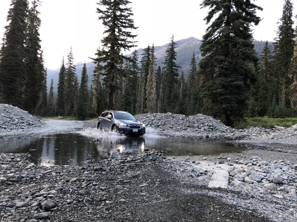
ROAD: The ford on FS 4330 to the camp is easy to cross but may be unsuitable for a small car. Water isn't too deep but may be impassable for some low-riders. Also, when navigating, Tucquala Meadows Trailhead is what to look for on Google Maps.

Mt. Daniel in a day via Lynch Glacier tagging the West Summit (7960), Middle Summit (7959) and East Peak (7899). 15h 5 min. car-to-car with a group of 6. After not finding much information on ascending via the Lynch we mapped out a plan on how to access the receding glacier in the summer when Pea Soup Lake isn't frozen (you can't exactly swim to the base with your climbing gear!) and successfully executed this plan.
We left the car at 4:05am (TH at roughly 3370ft elevation) headed down Cathedral Pass Trailhead and in about 2.5 miles in the dark, reached Squaw Lake on the left. About 1/2 mile later we reached a trail junction (about 5600ft) where the PCT hooks up with Cathedral Pass Trail. The trail is pretty mellow until this point...and absolutely covered in horse shit. Every few minutes I was yelling "Poop!" to the group so they wouldn't step in it in the dark. Make sure you veer left at the trail junction and continue along until you reach another trail that leads to Deep Lake (DON'T go left and down here, continue contouring right, you're now on the trail to Peggy's Pond), following the base of Cathedral Rock. The next section of the Peggy's Pond trail passed a few tiny bug-infested lakes, and then followed a loose, tiny, mountain-hugging bootpath along the base of Cathedral Rock (it was nice to not be hiking through this section in the dark...lots of loose dirt/rocks/roots/potential of rockfall from above and a large dropoff to Deep Lake below). Elevation gain and loss put us back at 5600 when we reached Peggy's Pond 2.5 hours and 5.5 miles into the climb (we were hauling ass, apparently!) Filtered water here with torrents of mosquitoes that 100% Deet couldn't keep at bay.
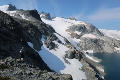
After Peggy's Pond, we navigated Northwest, crossing a creek, a few small snowfields and a glacial waterfall runoff, we ascended a slabby rock band and heather fields around a 6300 contour line passing the base of the Daniel Glacier. Contouring towards the ridge between Daniel and Lynch glaciers at around 6600, we were on a bench above Pea Soup Lake. We saw a few rock benches and snowfields we hoped we would be able to access the glacier from given that the glacier has receded to the point that the bottom few hundred feet is steep, broken blue ice with rocky runout into Pea Soup Lake. Scouting out the descent to the snow was harrowing given that the rock was just as shit as the horse poo and loose (big rocks, little rocks, shale, dirt, sand, kitty litter, whatever you want to call it, it WASN'T pleasant!!!) but we found a way down and carefully picked (slid with the scree) Northwest, hearts beating rapidly, until we all reached the snowfield below. Catching our breath on a rock island, we continued up on snow to the second snowfield and prayed we would find access to the glacier to avoid having to reascend that garbage we just came down. WE WERE IN LUCK! After continuing up the rock benches after the second snowfield we found a tiny section of snow that met the rocks on climber's left, with access to the Lynch Glacier (around 6700ft)! Roped up, crampons on, to ascend the glacier above the blue ice. Watch out for rockfall, there were plenty of rocks littering the glacier.
A few cracks on the lower glacier then a few LONG slim cracks extending the length of the glacier, and more opening up. We were able to cross with a tight rope and no pickets by traversing towards the middle of the glacier, and a few more cracks that were wider than a meter but able to navigate around. Make sure to probe, there were a few sketchy spots where an axe would easily find it's way under a melting snowbridge. Reached the top of the glacier and unroped on the rock band leading to the West Summit (high point) and scrambled up to the top (class 2/3). Descended, grabbed packs and headed to the Middle Summit (second-highest point), ascending on sometimes loose fist-and-foot-sized rocks, and scrambled up to the summit block (class 2). Headed down the scramble route, hitting up the East Peak on the way out. The East Peak is a bit more loose and exposed, but worth the trip in views. Descended then opted for a snow descent to climbers left of the ridge off the scramble route from the East Peak. Pretty steep entrance to the snow descent but much quicker than ascending and descending the ridgeline off the East Peak. Scrambled/hiked down back to Peggy's Pond, filtered more water, then hiked the 5.5 miles back to the TH.
Takeaways: Low-clearance vehicles may not make it across the ford at Scatter Creek on the road accessing the TH. Watch out for horse poop for the first 6 miles of the hike. Plan on at least 15 hours car-to-car. Leave early, but not too early, so you avoid the sketchy terrain around the base of Cathedral in the dark. There are plenty of places to filter water. You need mosquito repellant, they are relentless, especially under 6500 feet (basically the entire climb). If you're wanting to climb via Lynch Glacier, be prepared for sketchy terrain and sliding descents on very loose rock with bad runout to access the glacier. Route-finding can be difficult at times but as long as you know where you need to be, you can pick through the easiest terrain you can find to get there without waffling too much. It's a strenuous climb, especially in a day, and especially if you're planning on summitting more than just the tallest peak on the mountain. You'll want to be with partners who are fun to be around and have a good attitude...it's almost a 20 mile day! You'll want to wash off all the dirt and deet in the creek at the end of the climb. You'll want to get a burger (or Impossible Burger!)at The Brick in Roslyn on the way home because you'll be craving it.
 Liana Robertshaw
 Liana Robertshaw