Trip Report
Hike and Backpack the Lofoten Islands in Northern Norway
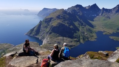
The Lofoten archipelago may be the most stunning place for backpacking, hiking and rock climbing that no one has ever heard of! During our 12-day adventure (starting in Bodø on the mainland and ending in Evenes at the north end of the archipelago) our group camped at 4 different lovely beach and alpine sites and walked up 7 different trekkers peaks, rode ferries to multiple roadless destinations, plus explored a number of the Lofotens’ most iconic fishing villages and stayed in two rorbuers, brightly colored seasonal fisherman’s cabins along the water that have been converted into comfortable tourist lodgings.
- Fri, Jun 14, 2019 — Tue, Jun 25, 2019
- Hike the Lofoten Islands in Northern Norway
- Day Hiking, Backpacking & Global Adventures
- Successful
-

- Road suitable for all vehicles
-
Weather is often wet and cloudy even during high season in the Lofotens, though we had more sunny blue-sky days than wet ones. Trails are well marked though some sections are up slabs with handlines, and hikes up some of the peaks can be quite scrambly and exposed in sections - check the trip descriptions in detail before you go! You'll need private transportation to see the islands as public transport is fairly limited to the best spots.
Our adventure began in Bodø, a coastal city of about 50,000 people located at 67 degrees north on the west coast of the Norwegian mainland. We found great lodgings, restaurants and places to shop for food and outdoor gear (though some typical backpacking supplies like powdered whole milk could not be found! They do have mostly fish-based dehydrated meals for sale). An early morning ferry took us on the 3.5 hour ride across the sea to Moskenes near the southern end of the Lofoten island chain. We met our guide and rental vans there (pretty hard to get around without personal transport) and or the next several days we either stayed in historic rorbuers – don’t miss these! - or carried our gear to camps, and from those base locations we hiked around lakes, to gorgeous out of the way beaches, and up to the top of several peaks for panoramic views. The peaks are uniformly very steep and rocky, and some are distinctly scrambly near the top (not all of us went all the way up), so you need to read the trail descriptions very carefully before setting out. The southern half of the Lofoten chain is narrow and broken up with a multitude of fjords and lakes so views are amazing and hiking distances are fairly short. In fact it’s difficult to string together a multi-day backpacking itinerary without considerable time spent on roads, but one of the highlights of our trip was three days in which we hiked in 7 miles to camp by a self-service alpine hut called Monkebu and explored the amazing alpine country and peaks in the vicinity. We were stunned by the number and size of the sheer granite rock faces everywhere along the islands, that surpassed Yosemite in their area and seemed to have absolutely no one climbing them. Perhaps it’s because the Lofotens are renowned for their unpredictable and often wet weather.
Trail guides, maps and signage are generally good so you would not have to have a guide, though with our larger group the guide really helped in showing us the best spots, lending an extra hand on the more precipitous routes, and helping us really enjoy the culture. Most everyone speaks English. Roads are narrow and windy – I cant imagine enjoying bicycling in this part of the islands! – and parking at trailheads can be jammed with tourists during the high season. The many fishing villages have retained their charm even with many tourist facilities. You won’t be able to help but notice the omnipresent cod-drying racks and sheds housing piles of peering cod heads – some of our trails passed under a rack of cod heads with it’s accompanying distinctive fishy aroma. We enjoyed many small cafes and great restaurants, though you really need to like fish to enjoy the culinary experience of the Lofotens.
- A google photos album of our Lofoten adventure can be found at https://photos.app.goo.gl/MsUwrwHmL3voGjX19
- Our outfitter (excellent!): Hvitserk https://www.hvitserk.com/
- Topo maps: Nordeca 1:50,000
- Gaia route maps: https://www.gaiagps.com/public/dDCt4sIyQrHShnCuYlyGIfrS (you'll need the Gaia Pro subscription to get the excellent Norway Topo mapset)
- For the best online trail descriptions and associated maps:
- http://www.68north.com/outdoors/hiking-introduction/
- https://www.rando-lofoten.net/en/
- https://outtt.com/en/norway/lofoten/hiking
For more details on our itinerary contact the trip leader Cheryl Talbert, cascadehiker@earthlink.net.
 Cheryl Talbert