Trip Report
Mildred Lakes
Rocky, rooty, steep and dangerous in places, this is more of a scramble than a hike for a significant part of the route.
- Sun, Jul 23, 2023
- Mildred Lakes
- Day Hiking
- Successful
-

- Road suitable for all vehicles
-
Trail starts out in ok shape but starts to deteriorate after about half a mile. Trail is easy to lose track of in many places as it wanders around boulders, over and around logs. There is a lot of up and down both directions on this trail.
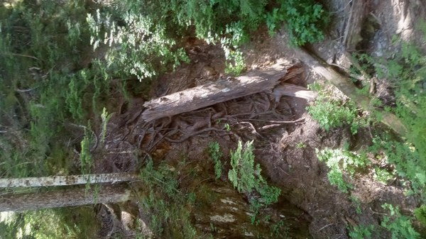
The first 2 miles end at a rocky and very cool viewpoint looking north. From here the trail drops to a creek and then begins the climb/scramble part. The trail goes straight up the ridge for about a mile and requires use of hands and feet in many places, with rock and root ladders and loose dirt. This photo shows a root ladder and the route goes up/down that root ladder which is about 75-80 degrees. This is just one example of this section of the route.

Root ladder on the route When this pitch finally eases out on an open rocky bench, the trail goes right/north and wanders around towards the lower lake. It is easy to lose track of the trail here as well due to the brush, stream crossings, navigating around mosquito ponds. The first lake is quite pretty and the rough trail continues with lots of ups and downs around the east shore to the inlet stream. Here is one last final root ladder climb up to another flat area of shallow puddles, rocks and open trees. Trail ends shortly thereafter at the upper lake, which is quite scenic. We did not visit the second lake today. Limited camp sites available at the lakes.
Made it down the rock/root "pitch" safely, but this section is definitely dangerous on the way down and requires extreme care and careful footing. The creek at the bottom of this pitch was a welcome sight! After this point the descent felt relatively easier but only in comparison.
In summary, I would argue this route is more of a scramble in many places. You also need good route-finding skills (we got off route many times) and to be very safety conscious, especially on the way down. Think good and hard before you decide to lead this with other people, you are taking a pretty big risk compared to most Mountaineers hikes.
Descending is even more dangerous than going up and we actually ran into a single hiker who had fallen and injured her knee and was waiting for Search & Rescue to show up. No way you can get a litter down that steep pitch without a ton of people and ropes and even then it would not be safe. Hopefully SAR can find a helo to pick her up.
Lakes are very scenic and if skies are clear the views are pretty sweet for a trip that tops out at 4000'. You won't see many folks on this route and there are good reasons for it!
Between the Putvin trail to LOTA, the trail to Upper Lena Lake and now the Mildred Lakes scramble bootpath, all in the Hamma Hamma river valley, I"m beginning to believe that "Hamma Hamma" means the valley of rocky, rooty hikes that go straight up.
 Brian Carpenter