Trip Report
North Slide Mountain
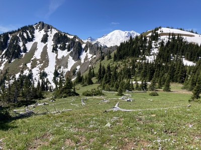
Beautiful alpine ridge roaming for low risk hunker relief. This private weekday outing avoided COVID crowds with only one other person encountered the entire day.
- Fri, Jun 26, 2020
- South Slide Mountain
- Scrambling
- Successful
-

- Road rough but passable
-
Snow free until ~5300’ elevation, and even then, snow was mostly on areas sheltered by trees or on north facing aspects. The Suntop Trail appears to be a popular venue for 2 wheeled vehicles doing a traverse, and the one person we encountered was on a motorcycle responsibly masked with a full head helmet/visor. Their engine noise allowed us to easily maintain a proper social distance.
Although Forest Road 7160 might be in good shape to the upper trailheads, we opted for a longer trip given our recent months in low land purgatory. From the end of the heavily vegetated FR7160-310 (~3000’ elevation, a tight squeeze with each of us driving separately), we hiked the Suntop trail to the Buck Creek crossing for the start of our cross country travel. After passing the lake on its eastern side we curved west to gain the expansive ridge crest alpine meadows.
We opted for less risk and more social time (properly distant) by skipping South and Middle Slide Mountains. From North Slide Mountain we opted to vet a future winter scramble venue with a different descent route. We headed north along the ridge crest to Point 5595, then descended the forested ridge NE to regain the Suntop Trail at ~5000’. Assuming winter time parking where FR 7160 leaves HWY 410 (29.1 miles from intersection in Enumclaw of highways 164 and 410), our descent route should make for a great winter scramble. Total time for this ~12 mile, 4000’ gain trip was 8 hours, with 2.5 hours ascending to the ridge crest, 3 hours for descent, and numerous socially distant confabs in the glorious meadows. Photos from this trip can be seen here.
 Dave Morgan