Trip Report
Sea Kayak - Chuckanut Bay
Excellent paddle day in a beautiful spot
- Sat, Jul 30, 2022
- Sea Kayak - Chuckanut Bay
- Chuckanut Bay
- Sea Kayaking
- Successful
-

- Road suitable for all vehicles
-
Unlike some days on this route, the wind was negligible. Breezes in the 3-5kt range. Might have been a couple of gusts pushing into the 7-8kt range. It was a hot day on land so the breeze felt good.
Launch point at Wildcat Cove was crowded with kayaks, paddle boards, crabbing and pleasure boats. Even more so on the return.
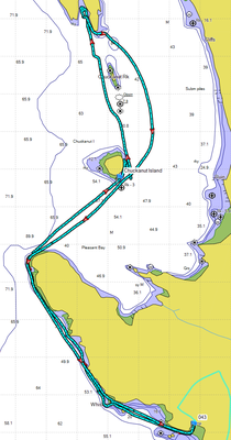
Launched at Wildcat Cove in Larabee State Park. We timed our paddle to take advantage of a low tide. Launched at 11AM on a falling tide. Low was at 1PM and a -1.3 so there was plenty of beach on Chuckanut Island.
Wildlife:
- Coming along the shore toward Governors Point, on Chuckanut Island, and in "Fossil Bay" we were pleased with the number and healthy appearance of purple and some orange sea stars. More than we've seen in several years.
- Spotted several mature and a couple of immature bald eagles, numerous harbor seals, and a variety of sea and shore birds.
Paddled north to and slightly around Governors Point then up to the sand/shell beach on the SE side/end of Chuckanut Island. This is a good place to stop, have lunch, and explore the tidal zone or scramble up and walk the unmaintained boot trail that circumnavigates the island. If you plan to scramble up to the trail it would be better to land on the NE corner of the island. The beach isn't quite as nice a landing spot but the access trail up to the top of the island is much easier. Just a trail rather than a scramble. A couple of us scrambled up the rock face on the SW face and intersected the trail. We walked counterclockwise until we came to the NE corner where we saw the easy trail down to the beach. We decided to descend to the beach and continue or exploration on the rocks on the west side of the island. At low tide there are plenty of choices to travel ranging from right down at the water level (watch the slippery rocks and plants) or up next to the cliffs. We continued our walk/scramble back around to the SE beach and our boats. Entire trek took about 35-40 minutes.
After our lunch, walks and explorations around Chuckanut Island we went to the NE end of the island and spent some time practicing various rescues. Because there was no real wind it was a great place to do this. Nice water, no close in power boat traffic, etc. Suggestion: don't practice rescues or rolling in Wildcat Cove. I know many people swim there (as they were today) but a ranger told me one time that the cove regularly records high levels of fecal contaminates because the numerous racoons use the drainage culvert from the parking lot above as a hideout. When it rains their feces is washed into Wildcat Cove
After Chuckanut Island we paddled north towards the small bay that some folks call Fossil Bay but I've never seen an official name on a chart. This is where you can see the erroded rock that could look a bit like fossilized palm tree trunks (but are not). Between Chuckanut Island and "Fossil Bay" is Chuckanut Island. This is a bird nesting sanctuary as well as a local hangout of seals and their pups. Stay well clear of the rock and don't disturb the wildlife. View from a distance.
From Fossil Bay there we paddled back down the bay on the east side of Chukanut Rock and Chuckanut Island. We chose not to head over to Teddy Bear Cove or to hug the shoreline although that is sometimes an interesting paddle.
Returned to launch site in Wildcat Cove about 4-1/2 hours after launch. Total distance right close to 7nm with a moving average a very stately 2.4kts/hour. Today was the reason that Chuckanut Bay is such a nice paddle. Of course all that changes when the wind rises so watch the forecasts.
 Bill Coady