Trip Report
Winter Scramble - Mount Teneriffe/Serendipity Ridge
Turned around just below the 4600’ elevation level due to avalanche concerns. Experienced two snow wind slab fractures where slope partially opens up below rock bands.
- Thu, Dec 16, 2021
- Winter Scramble - Mount Teneriffe/Serendipity Ridge
- Mount Teneriffe
- Scrambling
- Successful
-

- Road suitable for all vehicles
-
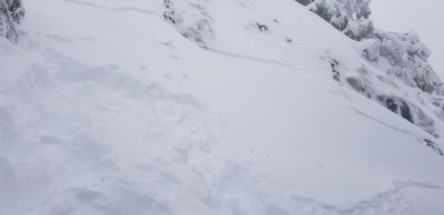
Key report focus is on avalanche concerns experienced at just below the 4600’ elevation level. A first wind slab fracture/movement of less than a foot by an estimated 50’ wide by 25-30’ tall by 4-5" thick snow slab was experienced climbers left of the wind loaded ridge line (West aspect). Movement was barely perceptible but a clear long horizontal fracture line was seen above and a horizontal rib at the bottom clearly delineated the slab. Snow depth is not known but we were nearly knee deep in our snowshoe track. This slab is shown in the included photo.
We then traversed climbers left further away from the ridge line on a slope that did not seem to be wind loaded and towards an angled snow ramp to the left of the rock bands and experienced another similar small slab movement and made the decision to immediately descend. A picture of the second slab fracture is included in the trip report section below with limited visibility of the actual fracture as it followed movement away to a safer location.
It is difficult to determine size with the minimal movement but presume D1 or D2 size had the slabs continued to slide.
NWAC avalanche forecast near tree line was low and moderate for the two zones that this location borders (west slopes central and Snoqualmie Pass respectively). Wind loading/slabs was the key concern noted in the forecast which was the likely key contributor to the slab fractures and slight movement we experienced.
A single measurement about 50 feet below the slab areas indicated 4 feet snow depth on a slope angle of 30-35 degrees with snow appearing stable without noticeable wind loading.
An NWAC observation report submitted by Jerrick Linde is available at https://nwac.us/public-obs/8649/
High level summary as focus of report is on avalanche concerns resulting in turnaround ~200 vertical feet below the summit.
Trail was in good shape with snow starting where the trail crosses the talus slopes below the Falls. Participants made individual choice on traction devices beginning at and above the Falls with. Mix of boots only (no device), microspikes, and crampons utilized. Particular care in travel was required on the rock sections that were covered in light snow just above where the boot path reaches the ridge line. The entire group put snowshoes on at an estimated 3600’ (elevation was not noted at the time). Snow depth progressively increased as we ascended to our snowshoe track was roughly knee deep.
We turned around at just below 4600' elevation due to avalanche concerns noted in the route conditions.
We were the only group on the route above the waterfall and we crossed paths with very few hikers from the Falls to the parking lot which was nearly empty on this Thursday in December.
 Craig Kartes