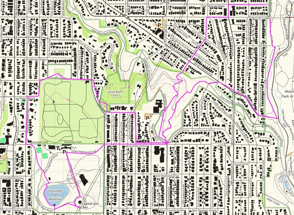
It was one of the rare late winter weeknights with a full moon and a clear sky, but I missed a turn. Our Seattle Stairway Walks hiking group was passing several back doors (or were they front doors?) going up many unintended Magnolia steps. This was not the Gaia route I had planned and followed the prior week. Nor was it the highlighted route on the map tucked in my trouser pocket, or the same Gaia route on my iPhone.
We were chatting, ever so pleased to be outside with headlamps, and I had turned a block too soon. The fault was not in the route, the paper map, or the iPhone map – it was the trip leader.
More than 560 publicly accessible staircases wander throughout Seattle's gardens, district neighborhoods, and urban nooks and crannies. Seattle Stairway Walks: An Up-and-Down Guide to City Neighborhoods is the city's first guidebook to 25 of the best neighborhood walks that feature public Seattle stairways. I’ve planned and led 17/25 of the Seattle Stairway Walks since January.
As my experience shows, navigation can be tricky - even when you have all the tools and know-how. Here are some tips to help you along way and plan your next adventure.
Tools to plan your own Urban Adventure
Below are the steps I’ve come to follow in creating new, urban adventure day hikes.
Use Gaia To Detail the Route
Several digital and hard copy tools are available to map a detailed route. I start with any recent guidebooks and hard copy maps at hand. The City of Seattle publishes large format city walking maps and several fold out city maps I find helpful for big picture planning
EDITOR'S NOTE: MOUNTAINEERS MEMBERS ENJOY DISCOUNTED ACCESS TO THE GAIA APP.
Use The three most powerful Seattle city walk books:
- Seattle Stairways Walks. This turn-by-turn walker’s guide provided a first rate template for our walks. Many were amended to add some miles and points of interest.
- Discovering Seattle Parks. The newest title brings fresh detail to the inevitable passage through or to 122 Seattle and Regional Parks.
- Seattle Walks. Rich in historical, cultural, geological, and natural world details, the walks make up in density what they lack in length or elevation gain.
Set your Criteria. My particular requirements for this series are:
- 2-2.5 hours with a 6pm start
- Easy+ over about 4 miles at around 2 mph including cultural and natural history stops
- Maximize stairways – many do these for conditioning
- Pass by or through one or two special places
- Be mindful of safety concerns at night in the city
Go time
Resources at hand, I open Gaia (these were done in Classic, not NextGen) and go to the Route function. In using Gaia, I've learned to:
- Zoom the map large enough to cover the first half hour (about 1 mile) of the route.
- Make sure I’m using WGS83 and have UTM coordinates activated – the grid squares will be 1km on a side for easy distance calculating.
- Tap the cursor at the TH and continue (slowly) clicking at turning intersections. You’ll likely need to wait for Gaia to connect the dots, which simultaneously generates a graphic route profile.
- Loop rather than out-and-back to explore more territory. The developing route profile tells me if I’ll likely stay close to my distance/time parameters.
- Save and print a BW map after closing the loop at the TH. Gaia is optimized for 8.5 * 11” paper but sometimes I do one or two screen grabs to paste, then print a custom Word doc.
- I return to the Mountaineers widget with actual, on-the-ground distance and elevation measures in hand.
Mountaineers Web Work
- With or without a guidebook to set a precise route, plan a general route.
- Go to Routes & Places (under Volunteers, Schedule an Activity) and key your anticipated route title to see if the trip or place already exists. For example, “Queen Anne” will generate a trio of options. If the description is pretty close, use it to post your hike with leader notes indicating how you will actually lead a modified hike.
- If not, you’ll create a new draft route or place using The Mountaineers widget to provide the essential information. I copy and paste from earlier entries to maintain parallel formatting. But you’ll need distance, elevation gain and high point data (see Gaia Route Details below).
- Once submitted, you’ll need to wait for approval (and likely some style and content edits) from IT Manager Jeff Bowman, an expert on trails and places. Jeff has a good eye for language and information that will work for the many trip leaders, not the few.
With a Mountaineers approved new place/route, I’m ready to post the hike, then test walk the route. I make notes on the backs of old business cards. They resist a little damp and can be alligator-clipped and cupped in your hand for ready note taking. While I could cut corners and speed through parks, lingering gives me grist for narrating the walk later. I introduce tiny mysteries to be solved along the route with careful attention to passing details – a brass benchmark, a hidden path entrance or site of an historical event. And I lay down a track to send to the assistant leader and for later reference.
At home I highlight the intended path and fold the map to fit into a sandwich bag. Over time, I began inserting north arrows to keep me oriented. A second copy goes to the sweep. The hard copy trip roster fits nicely in the bag, too.
While the iPhone app provides near absolute point position, I mostly use the tiny hard copy map as it comes to hand so easily and I save the phone for photos. Headlamps really help for reading in the dusk or dark. Starting the hike is optional; returning with all who started is essential. That head-mounted string of lights tells drivers, “Mountaineers crossing the street. Beware.”
An unanticipated benefit of frequent Gaia use was advancing from an informed novice to a comfortable intermediate user, better prepared to problem solve and teach others in the city or in the mountains.
Peter Hendrickson has decades of city hikes behind him, most recently circumnavigating Manhattan and Brooklyn Boroughs, making long forays around Zurich, Bolzano, Bariloche, and London, and enjoying midnight strolls through Buenos Aires and Bogotá. Contact: p.hendrickson43@gmail.com.
This article originally appeared in Navigation Northwest, a quarterly publication issued by The Mountaineers Seattle Navigation Committee. To view read more stories from the publication, click here.
 Peter Hendrickson
 Peter Hendrickson

