Author Regina Robinson explores a new topic each month in her "Did You Know?" series, which comes out in the Olympia Branch Newsletter.
The Hummocks-Boundary Trail is a great way to get up close and personal with Mount St Helens and gain a new perspective of the May 1980 eruption. The trail is located within Mount St. Helens National Monument in the Gifford Pinchot Forest.
Triggered by a 5.1 earthquake, the hummocks are debris avalanche remains from the Mount St Helen’s eruption on May 18, 1980. The volcano’s northern flank collapsed into the North Fork Toutle River, creating fast moving rock, soil, and snow. This debris avalanche sloshed and surged about 3.3 billion cubic yards of material 14 miles down valley, leaving behind steep sided, barren hills 150 feet deep. Those hills are not so barren 38 years later.
On the day we hiked the Hummocks-Boundary Trail, it was 32 degrees and starting to rain with a light mixture of snow. I figured we were in for one very wet, cold hike, with a dreary limited view. Much to my surprise, many times throughout the day, the clouds would part revealing bright blue skies that illuminated the landscape and created a mystical magical backdrop to our adventure.
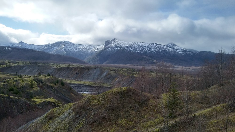
We started this 2.4 mile meandering loop, counterclockwise. The trail showcases small ponds, wetlands, several beaver ponds, and open meadow areas creating a unique complex habitat for birds, elk and other animals. Our first viewpoint of the North Fork Toutle River was breathtaking. The sleet had all but stopped, and the clouds parted to reveal a green, gray, and brown landscape covered with a light dusting of snow.
Overlooking the river, we could see the path it cut through the steep hummocks, revealing a river valley still in transition, where old growth firs used to stand, now alder and shrubs are making their way back, providing food and much needed habitat for animals. As we continued to hike on, we hoped that the clouds shrouding Mount St Helens would allow us a view of the mountain
.  Boundary Trail Sign | Photo: Regina Robinson
Two miles in, we reached the junction for the Hummocks Trail #229 and the Boundary Trail #1 to Johnston Ridge. Here we read the placard describing the ‘debris avalanche’ as a newly recognized volcanic hazard discovered by geologist and scientist studying the eruption. While we took advantage of the parting clouds and enjoyed a much needed sun and snack break, we were serenaded by croaking frogs and a pack of yipping, barking coyotes. After our snack, we decided to really take full advantage of the sun and blue skies and head up hill towards Johnston Ridge, even though we could still not get a glimpse of the elusive Mount St Helens.
We started gaining elevation, and snow came down hard as we made our way up the ridge. The clouds parted, the sun and blue skies came out, bring with them views of the hummocks and the North Forth Toutle River. Mount St. Helens continued to be cloaked in dense white clouds. We decided to keep going just a little further. Our goal was to reach a stand of snow encrusted noble firs where we would sit down and eat lunch. The sun and blue skies held, making it very easy to keep going.
After lunch, we decided to continue though the noble firs a mere .25 miles from the Loowit Viewpoint. The wind picked up and the snow started again. At this point we were 3.24 miles up the trail and nearing our turnaround time. We made the wise choice to turn around and head downhill to finish the Hummocks loop where we took our time reading more placards describing many interesting facts regarding the habitat, water, animals of the Hummocks.
You can view more photos from the trip online.
Trip Facts
- Elevation: 4314
- Total Ascent: 2500
- Moving Time: 5 hours (we kept stopping to take photos, admire the view and take sun breaks)
- Total Distance: Hummocks Trail 2.4 miles + Boundary Trail 3.24 = 8.88 miles
- Required Passes: No pass required at the Hummocks Trail
- Dogs: No pets, stock, or bicycles, off trail travel prohibited
How we got there
From Olympia, take Interstate 5 South to Exit 63. Take a left on State Route 505 toward Winlock/Toledo, follow it through to where it intersects with SR 504. Take another left and continue beyond the Science and Learning Center at Coldwater by bearing right at the interchange toward Johnston Ridge. Go about another 2 miles, just beyond the turn for Coldwater Lake. On your right will be the Hummocks Trail parking lot. At 94 miles, this drive takes about an hour and 45 minutes.
Additional directions
From Castle Rock, WA head east on State Highway 504 (Spirit Lake Highway) for 42.7 miles take the right branch and stay on 504 and drive another 2 miles to the Hummock/BoundaryTrail on the right.
Suggested items and ideas for the hike
10 Essentials, camera for taking photos, tell a trusted friend of your hike plans and your expected arrival time home, and don’t forget to bring your sense of wonder and adventure.
Tips
- With a drive time of almost 2 hours, I like to make a second breakfast to eat as we near the trail head, this wards off hunger and really fuels me in cold weather.
- During the summer, the Hummocks trail can be shady, but heading up towards Johnston Ridge on the Boundry #1 Trail it has no shade and is often very hot and dry with no water available.
 Regina Robinson
