In April, President Trump issued an executive order calling for a review of National Monuments designated under the Antiquities Act. Following the order, The Department of the Interior announced a public comment period for 27 specific National Monuments designated in the last 21 years. This review is unprecedented, and we encourage you to speak up in defense of these important public lands.
One of the National Monuments under review, Hanford Reach, is in our home state of Washington. Longtime Mountaineer and Mountaineers Books author John Roskelley recently took a trip to Hanford Reach and shares the experience.
Update: The good news is the Hanford Reach National Monument is no longer under review and its protections will remain intact. However, the future of other National Monuments remains uncertain. We hope the administration listens to the million+ public comments submitted in favor of our National Monuments and abandons any ill-advised effort to undermine them. Thanks to everyone who joined us in submitting comments in favor of Hanford Reach and our National Monuments!
By John Roskelley, Alpinist, Kayaker, and Mountaineers Books Author
Paddling the Hanford Reach is something every Washingtonian needs to do. It’s a bucket-list item, like climbing Mt. Rainier or hiking portions of the Pacific Crest Trail. Established in the year 2000, it’s named after the Hanford Reach, the last free-flowing, non-tidal section of the Columbia River in the US. The Monument was created mostly from the former security buffer surrounding the Hanford Nuclear Reservation, and has been untouched by development or agriculture since 1943.
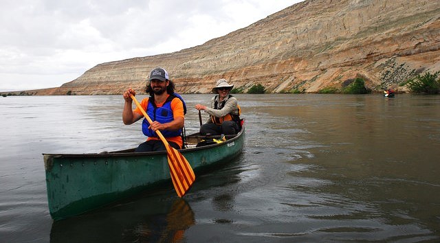
Seven of us met this past May at the Jackson Creek Fish Camp, a recently built Grant County PUD campground along the shoreline just two miles south of Priest Rapids Dam, to paddle the Reach. The Columbia was running near 270,000 cu/ft./sec - an unusually high flow for this time of year. Mother Nature had thrown us a curve (snow)ball over the winter and the Columbia was reaping the benefits.
At 9 am, we launched as a pod of American white pelicans flew up river and a coyote pack yipped and sang in an unusual daylight fiesta on the far side. Broadleaf trees along the banks of the river were standing in three feet of water and the usual rocky shoreline was flooded over.

The 196,000-acre Monument, located in the driest and hottest region in Washington, is in the Cascade rain shadow. Shrub-steppe vegetation predominates and, other than wildfire that occasionally burns miner swaths of the Monument, the land is relatively undisturbed brush habitat. As I noted in my guidebook, Paddling the Columbia: A Guide to All 1200 Miles of Our Scenic & Historical River, “…almost anything that grows, crawls, or slithers in this environment has evolved with some form of protection, such as thorns, stingers, or venom.”
Once into the main channel, we were swept past the canyon-like basalt cliffs and into the broad swaths of shrub-steppe. The water was clear, but unlike other trips I’d taken in the past, the depth prevented me from seeing the brilliant colors of the river rocks that make the Reach ideal habitat for spawning Coho salmon. Ducks and geese swam into the vegetation along the shoreline as we passed by, a common occurrence throughout the trip.
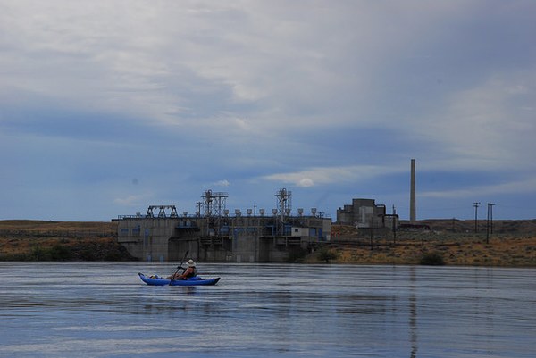
Within 45 minutes, we’d covered six miles to the usual put-in a few hundred yards upriver from the Vernita Bridge. Two miles downriver and only a quarter mile from the riverbank, Hanford’s “B” reactor, the only reactor open to guided public tours, rose above the flat nuclear reservation. The massive concrete pump house supplied millions of gallons of cool Columbia River water daily for the “B” reactor when in operation, an ominous relic of America’s race to create the first plutonium bomb. The Hanford Nuclear Reservation, although historically fascinating, is not part of the Monument.
Michael and Alex, experienced canoeists and professional photographers, took to the north shoreline to investigate a small herd mule deer and hawks perched in the limited trees near shore. The rest of us followed downriver, fascinated with the orange and brown hues of the early summer grasses, layered with the light greens of sagebrush and darker greens where springs and small ponds provided life to more water-loving vegetation. To our south, the “K”, “N” and “D” reactors in what is known as the “100 area” disappeared behind us.

We made the turn north toward the White Bluffs, an impenetrable 400-foot thick barrier of multi-layered, clay-silt ice age flood deposits. The tight turn of the river – which literally smacks into the White Bluffs and takes a tight turn almost 180 degrees – created a monster eddy along the west shoreline. Under normal conditions, several white sandy beaches lay a few hundred yards from the mud cliffs, but not at this flow.
I paddled hard to break free from the eddy and finally found the main flow and was quickly swept into the wide expanse of river as the black and dark grey sky, which had threatened us all morning, dropped its load of rain. Fifteen minutes later we hugged the north bank and paddled hard to catch the eddy into the protected cove at the White Bluffs boat ramp, a little over 25 miles from our put-in.
We enjoyed watching yellow-head and red-wing blackbirds in the thick riverine vegetation at the boat ramp while eating our lunch. After a change to drier clothes, our group set off to cover the last 15 miles to Ringold Springs. This stretch is known for its large sandy islands, bright green vegetation, sloughs that harbor numerous bird species, and, toward the end of the paddle, irrigated crops along the hillside.
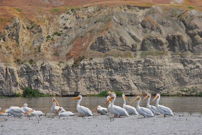
Periodic cloud bursts and dramatic black, blue, and white billowing clouds punctuated the afternoon paddle. One large pod of American White Pelicans decided to land on a gravel island in front of us. The birds were defiant and held their ground as we floated by, their long orange bills and brilliant white plumage contrasting with the brownish orange-colored hillsides, dark sky, and slate-grey river. Swallows darted around the boats, easily picking off insects that were swarming over the water while great egrets delicately worked the shallows along the islands and river shoreline.

The paddle went smoothly throughout the afternoon. We saw only one boat all day and after seven hours on the Reach, spotted the tell-tale high powered electric lines downriver, our take-out to the east. We hugged the shoreline to catch the final eddy into the cove at Ringold Springs to end a fine day through the Hanford Reach National Monument.
Your Voice Is Valuable
There is no question we must preserve this national monument as it has been designated. The Monument protects hundreds of species of mammals, birds, reptiles and invertebrates that may not survive without this unique and unusual habitat. To quote Aristotle, “The whole is greater than the sum of its parts.”
Thank you to Mountaineers Advisory Council member, American Whitewater PNW Stewardship Director Thomas O'Keefe for the photos!
 John Roskelley
