by Mickey Eisenberg, Gene Yore, and Kevin Bacher, NPS Ranger at Mt. Rainier National Park
Usually visitors to Mt. Rainier National Park admire grand vistas and the natural world surrounding them. This is as it should be, but in addition to the glory of the place are two large memorials and numerous plaques commemorating the people and human history associated with the park. This installment of Our Secret Rainier tells you how to find the two memorials and provides the location of the smaller plaques located throughout the park.
Memorial to Stevens and Van Trump –
first to climb Mount Rainier
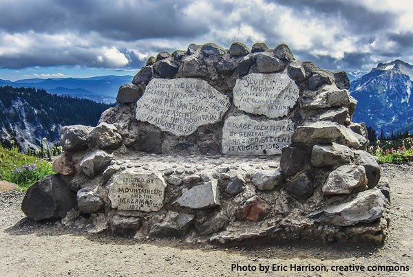
The memorial commemorates the first climb of Mount Rainier. The stones commemorating the event read: “Site of the camp from which General Hazard Stevens and PB Van Trump made the ascent of this mountain 17 August 1870,” “Sluiskin Indian Guide waited here for the climbers to return,” “Place identified by General Hazard Stevens 17 August 1915,” “Erected by the Mountaineers and the Mazamas 1924.”
The monument is located on the Skyline Trail near Mazama Ridge. It is in the shape of a seat so that one sitting can contemplate Mt. Rainier and imagine the route these intrepid climbers took to the summit
Directions: From the Nisqually Entrance drive to Paradise and in approximately 0.8 mile past Paradise and just beyond the bridge over the Paradise River, park in the large parking area on the right side of the road. Drive time to the parking area is 2 hours 30 minutes from downtown Seattle and less from Tacoma.
Route Description: The trailhead is located by a red “Wrong Way” sign on the east side of the road. Hike the 4th Crossing Trail for 0.2 mile until you reach the Skyline Trail, where you turn right (the sign points to Paradise Glacier, 1 mile). Continue on the Skyline Trail until you reach the Stevens–Van Trump Monument at approximately 6000’.

Side trip to Cowlitz Rocks: Fifty yards beyond the monument, follow the trail to Paradise Glacier (the sign states that the trail “ends 1.5 miles ahead”). Stay on this trail until it peters out, and then continue northerly with the Paradise Glacier on the left. Head up what appears to be a valley until you reach a col at 7200’, northwest of Cowlitz Rocks. Take the ridge (staying to the right, just off the ridge), and head southeast until you reach the highest point of Cowlitz Rocks (7450’). This final ridge portion of the route goes over rock scree.
Marine Memorial
On December 10, 1946 a military transport plane carrying 32 Marines from San Diego to Seattle encountered bad weather approaching Toledo, Washington and requested permission to fly above the storm. This last radio contact estimated the plane to be 30 miles south of Toledo, Washington. Immediate efforts to locate the place were hampered by the continued bad weather. The weather cleared enough by December 16th to launch an aerial search over an extensive area but no signs of the plane were found and in late December the search was suspended.
The following summer, wreckage of the plane was spotted by a park ranger on the South Tahoma Glacier at 9,500’. Extensive efforts to locate the bodies led to identification of a large piece of the forward section of the plane at 10,500’. Efforts to remove the bodies were considered too hazardous and the recovery mission was called off. The glacier remains the site of entombment for all 32. In 1947, the National Park Service dedicated a memorial to the 32 Marines located at Round Pass overlooking the Tahoma Glacier. A duplicate memorial was placed in the Veterans Memorial Park in Enumclaw. There is also a plaque with the names of all the Marines at the Jackson Visitor Center.
Directions: Drive one mile past the Nisqually entrance of Mt. Rainier and turn left on the West Side Road. Drive 3.2 miles until you reach a barrier - park here.
Route description: Walk or bike approximately 4 miles along the West Side Road to Round Pass. The Memorial is located immediately beyond the pass.
Side trip to Gobblers Knob: From Round Pass it is an easy hike to the Gobblers Knob lookout. The trailhead is at the pass. The hike to the lookout adds 1200’ and less than 3 miles round trip.
STEVENS/VAN TRUMP AND MARINE MEMORIAL
- Skill levels: easy hike (for both)
- Beauty: 6 for Stevens/Van Trump, 3 for Marine Memorial
- Effort: 2 and 3, respectively
- Distance (RT): 3 miles and 8 miles
- Elevation gain: 800ft and 1,100 ft
- Total time: 2 hours (Stevens) and 4 hours (Van Trump)
- Best season: summer & fall (for both)
- Maps: Green Trails Rainier East & USGS Rainier East for Stevens/Van Trump
- Green Trails Rainier West & USGS Mt. Wow for Marine Memorial
- Equipment: hiking gear (for both)

WWII Memorial Plaque
There’s also a small monument and plaque along the Waterfall Trail at Paradise, not far above the visitor center, commemorating the 10th Mountain Division that trained at Paradise during WWII before fighting in the Italian Alps. To find the plaque take the trail up from the plaza where the old round visitor center used to be, to the point where it intersects with the Waterfall Trail, the monument is on a low stone northwest of that intersection.
Want to learn more?
Mount Rainier National Park has over 100 climbable peaks (not counting Mount Rainier itself) either within or immediately adjacent to the Park boundary. While most are scrambles (and a few are climbs) there are 15 peaks that are reachable as hikes.
Guide to 100 Peaks at Mount Rainier National Park is available as an enhanced iBook for the iPad on iTunes and a PDF eBook by Mountaineers Books – all royalties are donated to The Mountaineers.
 Gene Yore
 Mickey Eisenberg