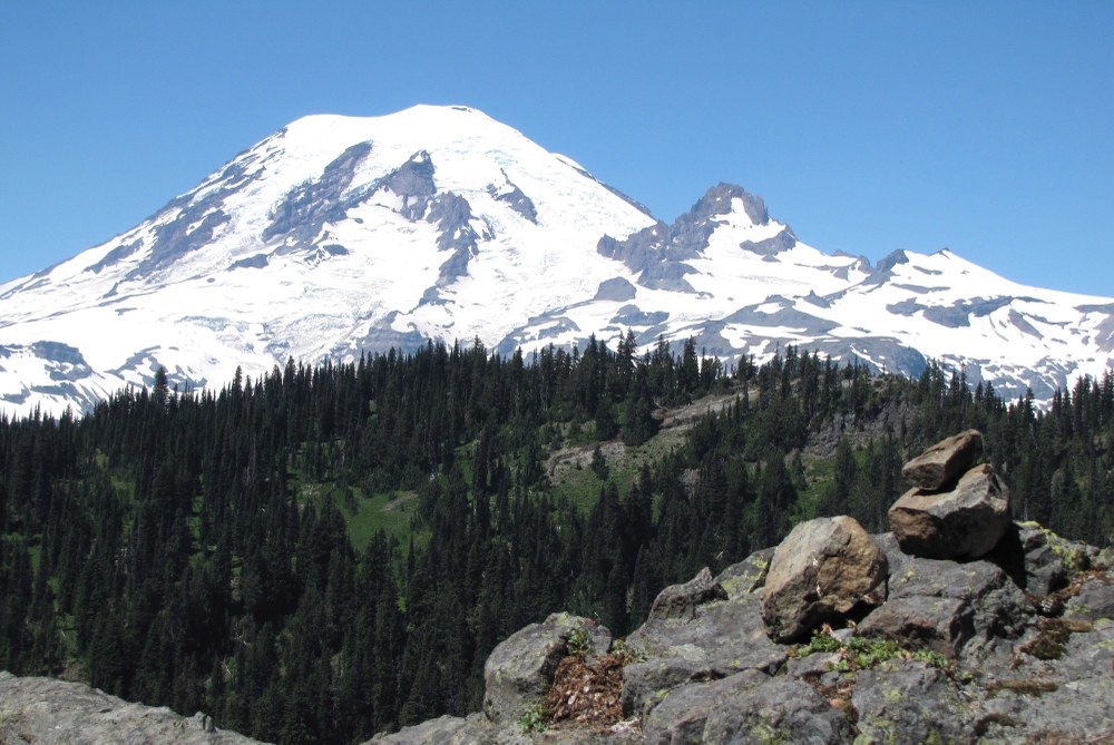
Bald Rock is infrequently visited but it makes for a lovely
forest hike with great views of Rainier and Little Tahoma.
The peak is named for it smooth treeless summit.
By Mickey Eisenberg, Gene Yore, and Steve McClure.
Bald Rock
- Skill: Easy scramble, mostly a hike
- Beauty: 6 (out of 10)
- Effort: 4 (out of 10)
- Distance RT: Stevens Canyon: 10 miles, Box Canyon: 8 miles
- Elevation gain: Stevens Canyon: 3,100 feet, Box Canyon: 2,600 feet
- Time RT: Stevens Canyon: 7 hours, Box Canyon: 6 hours
- Season: August through October
- Equipment: Scramble gear
Directions: Bald Rock can be approached from two trailheads. The Box Canyon route is the shorter of the two.
Stevens Canyon: From the Stevens Canyon Entrance, drive 0.8 mile east on the Stevens Canyon Road and park on the roadside at elevation 2,320 feet, where the road intersects the Cowlitz Divide Trail. (The trailhead is 15 miles south of the Crystal Mountain ski area turnoff and 33 miles east of the Nisqually Entrance.)
Box Canyon: This trail also leaves from the Stevens Canyon
Road and is approximately 10 miles west of the Stevens Canyon
Entrance (or 23 miles east of the Nisqually Entrance). Park on
the south side of the road at Box Canyon, and look for the Wonderland Trail sign.
Route: Stevens Canyon: Look for the Cowlitz Divide Trail sign.
Hike in a mostly northerly direction for 1.5 miles; then the trail
veers westerly. You will pass a sign to Olallie Creek Camp-ground in about 2.4 miles from the trailhead. The trail reaches a saddle at 4,760 feet, where it intersects the Wonderland Trail. Take the right, or northerly, trail and follow it for approximately 0.5 mile. At around 5,350 feet, leave the trail where it reaches an open meadow on the right and head in an easterly direction. Soon you will be on a ridge. Descend around 250 feet in 0.4 mile along the ridge passing over three bumps until reaching the lowest point on the ridge (5,100 feet). Then regain elevation and in 0.3 mile reach Bald Rock at 5,409 feet. There are a lot of elk trails along the ridge. You can follow one or merely stay on the ridge.
The north face of Bald Rock is extremely steep, but the summit
area is flat.
To return, retrace your steps or take a shortcut by returning to
the saddle at 5,100 feet. Descend the slope at a bearing of 200
degrees for 400 feet and then change your bearing to 178. You
will rejoin the Cowlitz Divide Trail at approximately 4,450 feet.
Return to trailhead.
This option is mostly on the Wonderland Trail. It is shorter than the Stevens Canyon route and has the attraction of crossing Box Canyon, a remarkable slot canyon in the southeast part of the park. The trailhead is across from the parking area and just east of Box Canyon and the Cowlitz River. Find the Wonderland Trail sign and head in the direction of Nickel Creek Camp and Indian Bar Camp. Follow the trail until it reaches a saddle at 4,760 feet. Stay on the Wonderland Trail, heading northerly. As with the Stevens Canyon route, leave the trail around 5,350 feet and head in an easterly direction. Soon you will be on a ridge. Descend around 250 feet in 0.4 mile along the ridge passing over three bumps until reaching the lowest point on the ridge (5,100 feet). Then regain elevation and in 0.3 mile reach Bald Rock at 5,409 feet. There are a lot of elk trails along the ridge. You can follow one or merely stay on the ridge. The north face of Bald Rock is extremely steep, but the summit area is flat.
Want to learn more?
Guide to 100 Peaks at Mount Rainier National Park is available as an enhanced iBook for the iPad on iTunes and in tablet eBook and smartphone eBook by Mountaineers Books.
MAIN IMAGE a View of Rainier and Little Tahoma from the summit of Bald Rock. By Mickey Eisenberg.
This article originally appeared in our Summer 2018 issue of Mountaineer Magazine. To view the original article in magazine form and read more stories from our publication, visit our magazine archive.
 Gene Yore
 Steve McClure
 Mickey Eisenberg