By Mickey Eisenberg, Gene Yore, and Steve McClure
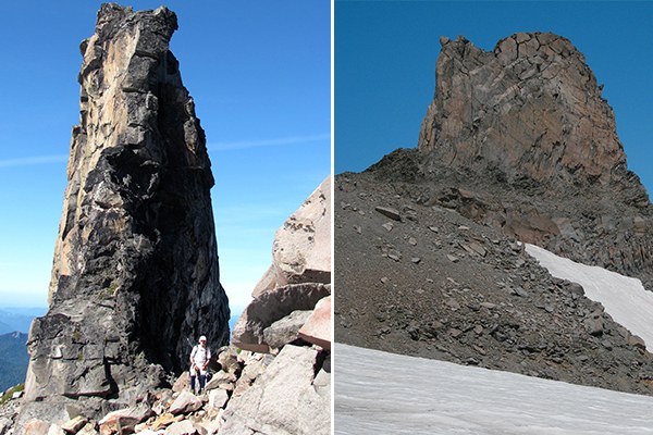
This installment of Our Secret Rainier takes you to the two spires of Mount Rainier – K Spire and Tokaloo Spire. We have visited both but have not climbed them, and we know only one individual who has climbed Tokaloo Spire. Fred Becky in his Cascade Alpine Climb, Volume 1, describes both as class 4 climbs. We include them in this installment of Our Secret Rainier because they are unique formations within the park and worthy of a visit – regardless of whether you stand on the top or not. Anyone contemplating climbing the spires should be an experienced climber and consult the Becky reference though details are sparse.
Tokaloo Spire
Route
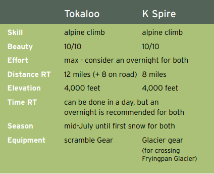
Travel by bike on the decommissioned Westside Road for approximately 3.6 miles to Round Pass. Stow your bike and start on the Round Pass Trail (the trailhead sign is on the east side of the road approximately 100 yards south of the Marine Memorial sign). In 0.6 mile the Round Pass Trail meets the South Puyallup River Trail. Hike east on the South Puyallup River Trail for 1.6 miles until it intersects the Wonderland Trail at 4200’. Turn left (north) on the Wonderland Trail and immediately cross the South Puyallup River. Continue northward. At around 6000’ (before you begin to descend on the trail), leave the trail, heading east and then northeast on a gentle ridge. There is a footpath on the ridge and the path continues past Andrew. Staying to the south of Andrew (or staying on the path), continue northeasterly toward Tokaloo Rock. The Spire prominently pokes up from the ridge leading to Tokaloo Rock.
Notes
Even with a bike this trip is long. We recommend visiting on a clear day as the Spire is in a spectacular part of the park. The Spire is very close to Tokaloo Rock, one of the 100 Peaks at Mount Rainier. To reach Tokaloo Rock pass the Spire and travel on the south side of Tokaloo Rock going past the summit and doubling back on the ridge to the summit.
We recommend August or September as perfect months to visit Tokaloo Spire. We also recommend an ice ax and traction devices. Snow is present on part of the route (and can be hard in the mornings) almost year round. And don’t forget the bug repellent. Andrew could easily be climbed on the way to Tokaloo Rock. The andesite columns, just before reaching the South Puyallup Camp, are awesome and remarkable – truly a geological gem. It would also be possible to bike the Westside Road to the South Puyallup River and climb Aurora, Andrew, and Tokaloo Rock all in a (very long!) day. A more relaxing way to climb these three peaks would be to obtain a back-country camping permit and camp overnight in the Andrew area.
Driving Directions
From the Nisqually Entrance, drive 1 mile and turn left on the Westside Road. Drive 3.2 miles until you reach the parking area at the road closure. The road was closed at this spot owing to large rock fall just beyond. A sign urges you to proceed quickly through the rock fall area.

K Spire
Route
Hike the Summerland Trail to the shelter at 5960’. From the shelter, head southwest at a bearing of approximately 220 degrees, ascending the best terrain. Stay to the right of a rocky cliff band. We suggest going up a grassy treed rib on the right of the rocky cliff band. There are climber paths heading up. At about 6800’ bear slightly to the left at an approximate bearing of 170 until gaining a low point on the ridge (elevation 7000’). Once over the ridge you will be in a large basin (snow-filled until late summer). Continue south (bearing approximately 150) to the low point on the next ridge, which connects Meany Crest to Peak 7573’. From the ridge, turn right until reaching the flat plateau (labeled 7573’ on the USGS map). When snow is present it is also possible to kick step up the snow directly to the plateau. Once on the plateau head west onto the Fryingpan Glacier and continue westerly to K Spire.
Notes
K Spire can be visited in a very long day. Better would be to camp on the plateau by Meany Crest. Glacier gear (ice ax, crampons, harness, ropes, etc.) is needed for crossing the Fryingpan Glacier, which often has glare ice in late summer. We suggest mid-late July as an optimal time to visit. K Spire is in the vicinity of Meany Crest (a scramble), Whitman Crest (a climb), and of course Little Tahoma (a climb).
K Spire was named in honor Cornelius “K” Molenaar who along with Dave Bodenburg were the first to climb the spire in 1951.
Driving Directions
Drive SR 410 4.5 miles south of the Crystal Mountain ski area turnoff and turn right on Sunrise Park Road. Drive 4.5 miles, until you cross the Fryingpan River Bridge. Park just beyond the bridge on the right side of the road. The Summerland trailhead is on the west side of the road. The road to the Summerland trailhead generally opens sometime in June.
Want to learn more? Mount Rainier National Park has over 100 climbable peaks (not counting Mount Rainier itself) either within or immediately adjacent to the Park boundary. While most are scrambles (and a few are climbs) there are 15 peaks that are reachable as hikes.
Guide to 100 Peaks at Mount Rainier National Park is available as an enhanced iBook for the iPad on iTunes and in tablet eBook and smartphone eBook by Mountaineers Books. All royalties donated to The Mountaineers.
This article originally appeared in our Fall 2016 issue of Mountaineer Magazine. To view the original article in magazine form and read more stories from our publication, click here.
 Gene Yore
 GENE YORE