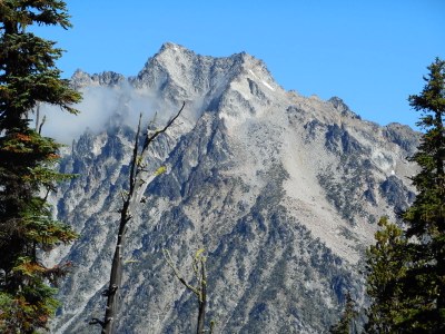
Mount Stuart/Cascadian Couloir
A nice snow climb in late spring and early summer. Fred Becky stated: "Without a rival as the crown peak in the central Cascades of Washington" in his second Cascade Alpine Guide. Steep snow in early season - bring crampons, rockfall dangers after snow melt. Road may be closed into June. Times: 3-4 hr trailhead to camp, 5-8 hr camp to summit.
Getting There
Drive on I-90 to about 1 mi east Cle Elum, then go northeast on SR 970 about 5 mi to 0.5 mi past the Teanaway River Bridge. Turn left on the Teanaway River Road and continue 23 mi to the road end parking area at 4,243 ft, about 1 mi beyond the DeRoux Campground (Forest Road 9737). Car camping is available at the DeRoux Campground and other campgrounds on the Teanaway River Road
APPROACH
From the parking area, hike abandoned mine road/trail for about 0.25 mi to fork in trail. Take the right fork (east) toward Longs Pass. Hike 4 mi up trail over Longs Pass (6,200 ft). Descend to base camp (4,800 ft) near Ingalls Creek. There is no water available on the trail until you reach Ingalls Creek.
ASCENT ROUTE
Cross log bridge at Ingalls Creek. Go east on trail about 0.25 mi to meadow. Can also camp here. Follow climbers trail up meadow and the Cascadian Couloir. Work up the couloir toward upper snow fields of the false summit.
Taking a good look at the route when at Longs Pass will help in route finding. There is a good picture in Cascade Alpine Guide, Vol 3 on pp. 299 & 301.
Crampons may be needed here. From false summit (9,200 ft) scramble east along left side of ridge through broken rock (Class 2-3) directly to summit (9,415 ft).
DESCENT ROUTE
Descend the climbing route.
TRIP PROFILE
EQUIPMENT
Standard alpine equipment and crampons.
NOTES
- This is a very long climb - be in very good physical condition.
- Use caution on the slopes below false summit - steep snow early in the year and loose rock later in the year.
- The presence of steep snow on the upper slopes makes this trip worthy of Basic Alpine Climb when done in the early season.
- The Teanaway River Road may be snowed in into June.
- Suitable Activities: Scrambling
- Seasons: June, July, August, September, October
- Weather: View weather forecast
- Difficulty: Technical 5, Strenuous 5, Basic Experience Climb
- Elevation Gain: 8,000 ft
- 9,415 ft
-
Land Manager:
Okanogan-Wenatchee National Forests
Alpine Lakes Wilderness
- Parking Permit Required: Northwest Forest Pass
- Recommended Party Size: 12
- Maximum Party Size: 12
- Maximum Route/Place Capacity: 12
- Green Trails Mt Stuart No. 209
- Green Trails Alpine Lakes East (Stuart Range) No. 208SX
- USGS Mount Stuart
- Green Trails The Enchantments No. 209S
There are no resources for this route/place. Log in and send us updates, images, or resources.
