Mount Price
Scramble a peak with a dominant vantage over the upper Middle Fork Snoqualmie River.
getting there
Take Exit 34 off of I-90 and turn left onto 468 Ave SE. In a half mile, turn right onto SE Middle Fork Road (Forest Road 56). Drive 12.5 miles and trun right onto Forest Road 5620. Continue 5 miles to the Dingford Creek Trailhead (1,400 ft).
approach & ascent
Standard Route
when snow is present in winter and spring
Hike the Dingford trail 2.1 miles with 4-5 creek crossings to Goat Creek (2,570 ft). Head on a bearing of 130° and find a log to cross Dingford creek. After crossing the creek, head uphill on a bearing 130° following the left side of creek and coming from an unnamed lake. If going up on the right side of the creek at first, cross over before going on past 3,450 ft. Try to stay in the timber to avoid brush. From the lake do an ascending traverse staying below the cliff bands to the saddle northwest of Little Hester Lake. To gain the saddle, go to the point below the saddle and ascend minor treed ridge about 60 feet, then scramble up some moss covered boulders a few feet, then to the saddle. Follow the ridge southerly to summit. It's 10 miles round trip with 4,100 feet of elevation gain.
- This route best done when snow present, lots of brush with devil's club after leaving the trail until 4,000 ft.
- Finding a route to gain the saddle northwest of Little Hester Lake may be difficult, only one route appears to go. An alternative may be to gain the ridge south from the outlet from the unnamed lake and run the ridge.
- In winter and early spring approach via northwest slope: Ford Dingford Creek or find log or snow bridge crossing, and navigate through cliff bands to Price Lake. Ascend the steep gulley at the south end of the lake or find a route up to ridges on either side of Price Lake. Run the ridge or take the northwest slope. The saddle northwest of Little Hester Lake at 4,680 ft is another option.
- In snow, the gully going up southeast from above Price Lake is wide and consistently moderate. It works very well to access the northwest slope, but avalanche conditions should be carefully evaluated.
- The most technical part of the scramble is following the gully of Price Creek between 3,200 ft and 3,800 ft. Though not verified, this might avoided by exiting the gully to climber's right below where the gully narrows at about 3,200 ft and traveling uphill west of Price Creek.
- Optional Decent Route: If snow present where glissade possible, drop off the summit to the east to the first saddle and drop 25 feet to the snow slope, glissade to 4,900 ft, then contour right to the next slope that goes all the way to Little Hester Lake and glissade.
Alternate Route
when the trail is snow-free in summer and fall
Hike the Dingford Creek trail 5.5 miles to Hester Lake. After passing the Myrtle Lake Trail, the trail is in poor shape. The trail is washed-out by the creek forking and destroying 0.2 miles of trail between 3,000-3,200 ft. The rerouted trail follows between the streams. Follow it on left side through brush until intersecting the trail or between the streams. The trail in early season has lots of water running down it. Continue cross-country through brush on the north side of the Hester lake to Little Hester lake, then gain the saddle northwest of Little Hester lake. Follow the ridge southerly to the summit. When snow is gone, the north ridge has one tricky move. It's 13 miles round trip with 4,100 feet of elevation gain.
Photo Info
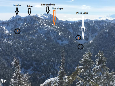
- This is a view of Mount Price looking from the north (summit of Sorcery Peak). The three numbered circles show the route options. (1) is the gully above Price Lake that worked very well for David Jusish in 2017. (2) is the ridge east of Price Lake that was their second choice. (3) is the saddle northwest of Little Hester Lake that Mike Torok took in the 90's.
Notes
- In 2017, a log to cross Dingford Creek with care can be found slightly upstream from the Price Lake outflow confluence with Dingford Creek.
FOr leaders
Permit information
As of 2017, the Snoqualmie Ranger District considers Mountaineers trips and courses to be "nominal use". Leaders should print and copy this designation letter to show rangers they may see on trail or carry a digital copy on their phone.
- Suitable Activities: Scrambling
- Seasons: Year-round
- Weather: View weather forecast
- View avalanche forecast.
- Difficulty: Strenuous 4, Technical 4, Winter Scramble
- Length: 10.0 mi
- Elevation Gain: 4,100 ft
- 5,587 ft
-
Land Manager:
Mount Baker-Snoqualmie National Forest
Alpine Lakes Wilderness, Snoqualmie Ranger District (MBSNF)
- Parking Permit Required: None
- Recommended Party Size: 12
- Maximum Party Size: 12
- Maximum Route/Place Capacity: 12
- USGS Snoqualmie Lake
- Green Trails Alpine Lakes West (Stevens Pass) No. 176S
There are no resources for this route/place. Log in and send us updates, images, or resources.
