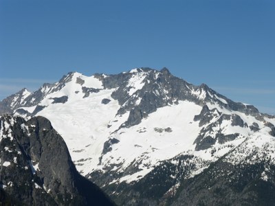
Mount Logan/Douglas Glacier
Mount Logan via the Douglas Glacier is rated Grade II, Class 4. A great multi-day climbing in the remote North Cascades.
GETTING THERE
Drive I-5, taking Exit 232 (Cook Road) at Burlington, turning east to Sedro Wooley and SR 20. Continue 47 mi to Marblemount for trip permits at Park Ranger Station. Continue to Easy Pass Trailhead and park, 3,700 ft.
APPROACH
Hike the Easy Pass Trail 3.7 mi to Easy Pass (6,500 ft). Descend to Fisher Creek and follow it's far side, contouring and losing elevation, following the path of least resistance until you are below the basin under the Douglas Glacier. Turn left (south) and travel cross country into the basin. Good camping available here.
ASCENT ROUTE
Ascend a snow gully or scramble rocks to attain the glacier. Climb the glacier to the col (steep at top). Ascend the 3rd-4th class summit block using the standard route.
DESCENT ROUTE
Descend the climbing route.
TRIP PROFILE
| SEGMENT | TIME (HR) | ELEVATION GAIN (FT) | ELEVATION LOSS (FT) | MILAGE (MI) |
|---|---|---|---|---|
| Seattle to Trailhead | 3.5 | 150 | ||
| Trailhead to Camp | 10 | 4,000 | 1,500 | ~13 |
| Camp to Summit | 6-9 | 3,000 | ~2 | |
| Summit to Trailhead | 13-14 | 1,500 | 7,000 | ~15 |
EQUIPMENT
Ice ax, crampons, small alpine rack.
NOTES
- This climb is best done early season to avoid bushwhacking.
- This is a great route for climbing Mount Logan in a reasonably-paced three-day trip.
- Suitable Activities: Climbing
- Climbing Category: Basic Alpine
- Seasons: June, July, August, September
- Weather: View weather forecast
- Difficulty: Basic Glacier Climb
- Length: 30.0 mi
- Elevation Gain: 8,500 ft
- 9,088 ft
-
Land Manager:
North Cascades National Park
Stephen Mather Wilderness
- Parking Permit Required: None
- Recommended Party Size: 6
- Maximum Party Size: 12
- Maximum Route/Place Capacity: 12
- Green Trails Mt Logan No. 49
- USGS Mt Logan
There are no resources for this route/place. Log in and send us updates, images, or resources.
