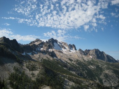
Silver Star Mountain/Silver Star Creek
Silver Star Mountain via Silver Star Creek is a strenuous but easy climb.
Getting there
Drive SR-20 (North Cascades Highway) to the winter closure at Silver Star Creek (east of Washington Pass).
APPROACH
Ascend Silver Star Creek along its east (left) side for 2 miles to a basin at 4,800 ft. Cross the basin to its west side. Ascend towards Burgundy Col, avoiding gullies near the basin's headwall. When the slope eases, head towards Burgundy Spire. Good camping is near 6,400 feet.
ASCENT ROUTE
Make a rising traverse south to subsidiary ridge, then continue rising on Silver Star Glacier to summit col. Careful route finding allows a scramble east to summit - look for the easy ramp about 40 feet below the summit. Otherwise you may encounter a short pitch of low 5th class climbing.
DESCENT ROUTE
Descend the climbing route.
TRIP PROFILE
EQUIPMENT
Standard glacier equipment.
NOTES
- Although this can be done as a long, one-day climb, the long drive and beautiful views of the North Cascades makes a two-day climb more enjoyable.
- Pickets may be useful to protect steep exposed snow.
- Also an excellent winter or spring ski tour.
- Suitable Activities: Climbing
- Climbing Category: Basic Alpine
- Seasons: May, June, July, August, September
- Weather: View weather forecast
- Difficulty: Basic Alpine Climb
- Length: 8.0 mi
- Elevation Gain: 5,500 ft
- 8,876 ft
-
Land Manager:
Okanogan-Wenatchee National Forests
Methow Valley Ranger District (OWNF)
- Parking Permit Required: Northwest Forest Pass
- Recommended Party Size: 12
- Maximum Party Size: 12
- Maximum Route/Place Capacity: 12
- USGS Silver Star Mtn
- Green Trails Washington Pass No. 50
- Trails Illustrated North Cascades National Park
