Field trip: Lookouts and High Places
Lookouts and High Places August Hikes - Shriner Peak
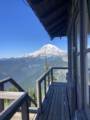
**Trip initially open to Lookouts and High Places Day Hiking Series students. Trip will open for registration to all Mountaineers 7 to 10 days prior to the hike date.** Shriner Peak is a strenuous, 8.4 mile round trip day hike with 3,400 feet of elevation gain. The trail is a steady steep climb through forests, burns and south facing meadows, up a ridge to the historic Shriner Peak lookout tower.
- Fri, Aug 9, 2024
- Tacoma Hiking & Backpacking Committee
- Day Hiking
- Adults
- Strenuous
- Challenging
- Mileage: 8.5 mi
- Elevation Gain: 3,434 ft
- High Point Elevation: 5,834 ft
- Pace: 2mph
- 10 (10 capacity)
- FULL (2 capacity)
- Cancellation & Refund Policy
Will meet at the Shriner Peak Trailhead, ready to hike around 8:30am.
From Enulclaw, drive 40 miles east on SR-410. At the fork continue straight onto SR-123 and drive 7.4 miles. Park in the pullout on the right. Cross the highway and walk ~80 yards southeast to the trailhead (2,400 ft).
I will be in a white Toyota Tacoma with a topper.
Good carpooling spot would be at the Enumclaw safeway, I'll most likely be stopping there to grab a coffee, snacks, etc.
Shriner Peak
-
Green Trails Mount Rainier Wonderland No. 269SX
Green Trails Mt Rainier East No. 270
USGS Mt Rainier East - See full route/place details.
Required Equipment
10 Essentials
